Subduction Zone Earthquakes
Mexico City EQ, 1985

- Time: Sep 19 1985, 7:17 a.m.
- Location: epicenter 50 km (~ 31 miles) off the coast
- Magnitude:
- 1st EQ Mw 8.0,
- 2nd EQ 36 hours later Mw 7.5
- Type Of Faulting: Normal
- Depth: 27 km
The epicenter for this earthquake was located off the coast of the Mexican state of Michoacán, nearly 350 km from Mexico City. Typically, intensity diminishes with distance from the epicenter. Yet most of the damage from this earthquake was in Mexico City. Why?
The reason lies with what Mexico City was built upon. The Aztecs built the city of Tenochtitlan on an island in Lake Texcoco in 1325. Over time the city expanded, the lake was drained, and is now the largest metropolitan area in the western hemisphere. The soft, wet, clayey sediment underlying Mexico City does not behave well during earthquakes. Sediments like this tend to amplify seismic waves. Thus the shaking becomes more intense and more damage is caused.
As the seismic waves traveled outwards from the epicenter of the earthquake, they lost energy the further they traveled. However, the soft, clayey sediments under Mexico City amplified them - much like a microphone amplifies a voice - causing the deaths of at more than10,000 people and serious damage to the Greater Mexico City Area. (Source 1, 2)
Damage:
- Affected area: ~825,000 km2
- 3 and 4 billion U.S. dollars of damage
- 412 buildings collapsed and 3124 damaged in Mexico City
- 60% of all buildings destroyed in Ciudad Guzman, Jalisco
- Felt by almost 20 million people.
Why was the damage so great?
- Liquefaction of lakebed sediments
- Buildings resonating at the same frequency of the ground vibrations
- Check out: http://www.johnmartin.com/earthquakes/eqshow/647003_00.htm (20 slides)
Cascadia Subduction Zone
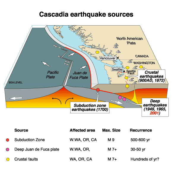
1700 Cascadia Earthquake
|
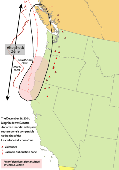
Time: Between 9:00 PM and 10:00 PM, local time, on January 26th 1700 Location: unclear, off the Oregon coast Magnitude: Mw 9.0 (est) Type Of Faulting: Subduction Fault involved: Cascadia Subduction Zone Depth: unknown Length of the fault rupture: ~1000 kilometers (600 miles) Average slip: 20 meters Average recurrence interval for earthquakes in this region is 400 – 600 years We’ll talk more about this quake later . . . . |
 |
2001 Nisqually Earthquake

|
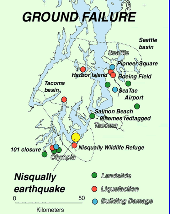
Damages - Ground Failure |
 |
|
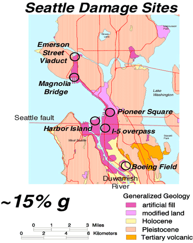
Damages - Buildings
|
 |
|
Damages - Human Death and Injury
|
Damages
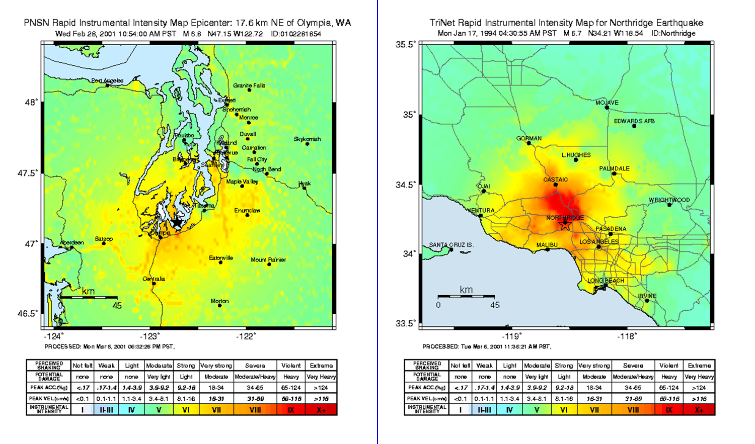
Why were the damages caused by this earthquake (Mw 6.8) less than that of the Northridge earthquake (Mw 6.7)? It is due to where the epicenter for each quake was located. The epicenter for the Nisqually quake was located in a relatively uninhabited area of Washington, while the epicenter for the Northridge quake was located directly beneath the city of Northridge.
Why was there no tsunami generated? Look at the map that shows where the epicenter for this quake was located. Is it on land, or in the ocean? In order for a tsunami to be generated, the earthquake would have needed to be located in the ocean and not on land.
Nisqually vs. Northridge
Future EQs in the Washington Region
1949, 1965 & 2001 EQs on subduction zone
- Plate young & warm, still pliable
- Seismic waves lose some energy the further they travel
- Numerous surface faults exist
- Damage will be much greater