Divergent Plates = two plates moving away from each other
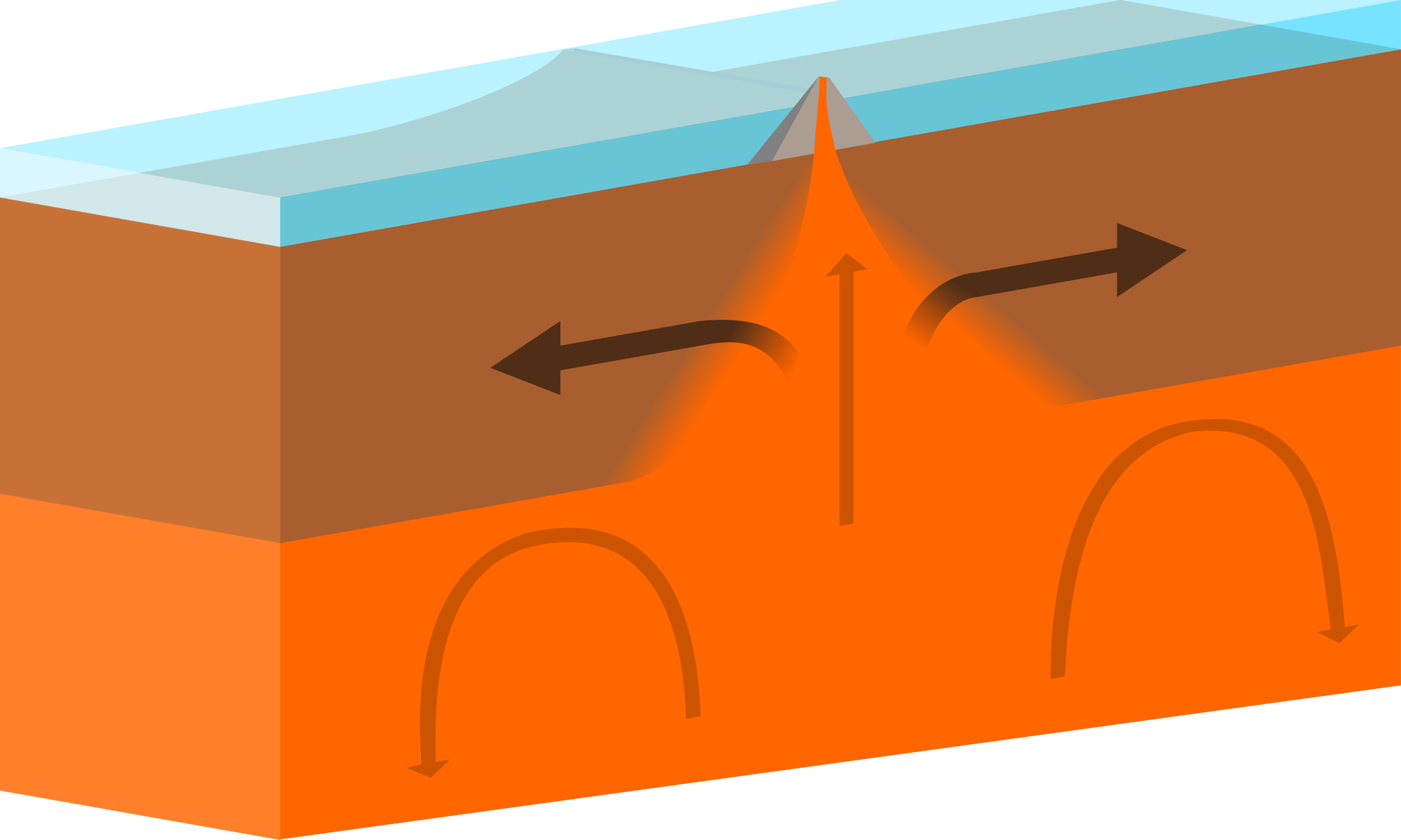
- Hot mantle material rises up
- Magma erupts to the surface
- Plates are pushed apart
Image source: "Oceanic-oceanic constructive plate boundary" by domdomegg is licensed under CC BY 4.0
Continental Rifting
How did Pangaea break apart? Recall on the previous page how for the North American and Eurasian plates one side was moving in one direction and the other side in a different direction. This creates tensional stress in the central portion of the plate. Also, recall that subducting oceanic plates and mantle convection cause the rocks in the asthenosphere to flow. This region of tensional stress is one place where this mantle material will flow to. As it puddles underneath the crust, it causes the crust to become warm and pliable. This causes the lithosphere stretches & thin. Eventually, the brittle upper crust begins to develop faults. The ductile lower crust begins to flows and the asthenosphere melts. This melted rock rises to the surface to create volcanoes. The flowing lower crust causes the plate to bulge upwards and thin even more. Eventually, the plate will begin to diverge, and the oceanic crust will form in the middle.

(Top) Lithosphere stretches & thins.
- Brittle upper crust faults, ductile lower crust flows.
- Asthenosphere melts, erupts at the surface via volcanoes in the rift zone.
- Plates are pushed apart.
(middle) Rift Valley forms
(bottom) Ocean basin forms
Image source: "Rifting to Spreading Transition" by Joshua Doubek is licensed under CC BY 3.0
So, how do basin and range mountains and valleys form (steps (a) and (b) above)? Watch this video, "How do basin and range mountains and valleys form?" by IRIS. As you do, note the following:
- What type of tectonic forces was at work to create the Basin & Range province?
- The description of how the province forms is similar to what is described in the stages of rifting image above. What stage is the Basin & Range province currently in?
Once rifting has begun, and, eventually, an ocean basin will form. There are three stages of progression:
- Rifting has begun and there is oceanic crust at the bottom of the rift zone. There may or may not be an inundation of seawater into the rift zone. Modern example: The East African Rift Zone or the Red Sea.
The dashed lines on the map below outline the East African Rift Zone,
which splitting Africa into two tectonic plates: The Nubian Plate on the west, and the Somali Plate on the east. Note the red triangles inside the rift zone; those represent volcanoes.
Now look north towards the Red Sea. There's a grey line there and in the Gulf of Aden. That line represents a spreading center. Millions of years earlier, the Arabian plate was attached to Africa. Rifting like what is happening now created the Red Sea and Gulf of Aden spreading centers. And, like in the East African Rift Zone, volcanoes dot the east side of the Red Sea, indicating that spreading is still very active in this area.
Eventually, water from the Red Sea and Indian ocean will flood the East African Rift Zone, and the Somali Plate will completely be separated from the Nubian Plate.
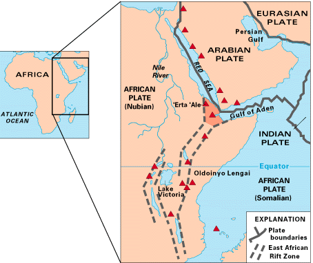
Image source: "Figure 18" by USGS is in the Public Domain
- The ocean basin is wide enough that there is now an ocean in it. Modern example: The North Atlantic Ocean near Iceland.
- The ocean basin is very wide and mature. Modern Example: The Atlantic or Pacific Oceans.
|
<< back |
|
copyright Sonjia Leyva 2022 |
|