Plate Tectonics |
||
In 1492, Columbus sailed the ocean blue . . . and pretty much ever since then, map makers have noted how similar the coastlines of South America and Africa were. It was almost as if the two had once been a whole that had been broken in two.
But how?
Abraham Ortelius in Thesaurus Geographicus (1596) suggested that the Americas were "torn away from Europe and Africa ... by earthquakes and floods". Many others agreed - after all, floods could do a lot of damage.
The 1800s saw the first real oceanographic studies conducted. In 1855, U.S. Navy Lieutenant Matthew Maury (The Maury Project) created a bathymetric map with the first evidence of underwater mountains in the central Atlantic. His findings were used to help determine how much cable was needed for a project to lay telegraph cables across the Atlantic. The project was completed in 1858, and the Transatlantic Telegraph Cable Company was able to confirm that there were indeed mountains in the Atlantic Ocean.
Enter into the story Doctor Eduard Suess (1831 – 1914) - no, not that Dr. Suess. Eduard Suess was an Austrian Geologist and an expert on the geography of the Alps. He was a respected geologist who put forth many ideas on the origin of the continents, but many of them were not quite correct. Some of these ideas include:
Suess believed in “Contractionism”, the idea that mountains, valleys, and other geomorphic features were a result of the fact that the Earth was shrinking as it cooled.
As a result, He also speculated that South America, Africa, and India were joined in the supercontinent “Gondwanaland” (semi-true) but were separated as ocean levels rose and covered up the land bridges. (semi-true). There are land bridges - the most famous are the Bering land bridge. separating Russia from Alaska and the Doggerlandland bridge. between England and Europe. The problem is that there isn't one between South America, Africa, and India. And there was lots of data from scientists like Charles Wyville Thomson . from the Challenger Expedition. and U.S. Navy Lieutenant Matthew Maury. to show that the ocean depths in those areas were far too deep to support the land bridge idea.
Visit the Buxton Museum to view an image of Suess's map of the world showing Gondwanaland.

Dr. Wegener was a German polar researcher, geophysicist, and meteorologist. He was first interested in polar meteorology but became interested in geophysics when he noted how well the continents fit together in 1910. He continued to study the continents while teaching at the University of Marburg and while serving in WWI (where he was wounded twice). He published his ideas on continental drift 1915 in a publication entitled Die Entstehung der Kontinente und Ozeane (“The Origin of Continents and Oceans”), but his ideas were a radical departure from the accepted beliefs of the time.
His primary evidence for this hypothesis are as follows:
Like everyone else, Wegener noted how nicely one side of the Atlantic Ocean fits with the other. Wegener called this supercontinent "Pangaea".
Below is a modern reconstruction of Pangaea, with the current plates outlined in black. Areas colored in red on the map represent were new land has been added and those in black represent areas where land has been eroded. Note where those red and black areas meet up - currently, the middle of the Atlantic Ocean. Dr. Wegener didn't know this at the time, but 200 million years ago Pangaea began to tear apart via a process called rifting (see Divergent Plate Boundaries), at first splitting the continent into two halves, with the Atlantic Ocean forming in-between.

Wegener also noted that the rocks on both sides of the Atlantic Ocean were metamorphic rocks, a type of rock that forms during mountain building events (like the Himalayas). Rocks are changed to a new rock type due to heat and pressures unlike that in which they first formed. They also followed a pattern: rocks at the center were subjected to the highest heat and pressure and had a specific set of rock types and minerals as a result, and rocks further away showed less heat and pressure and different rock and mineral assemblages.
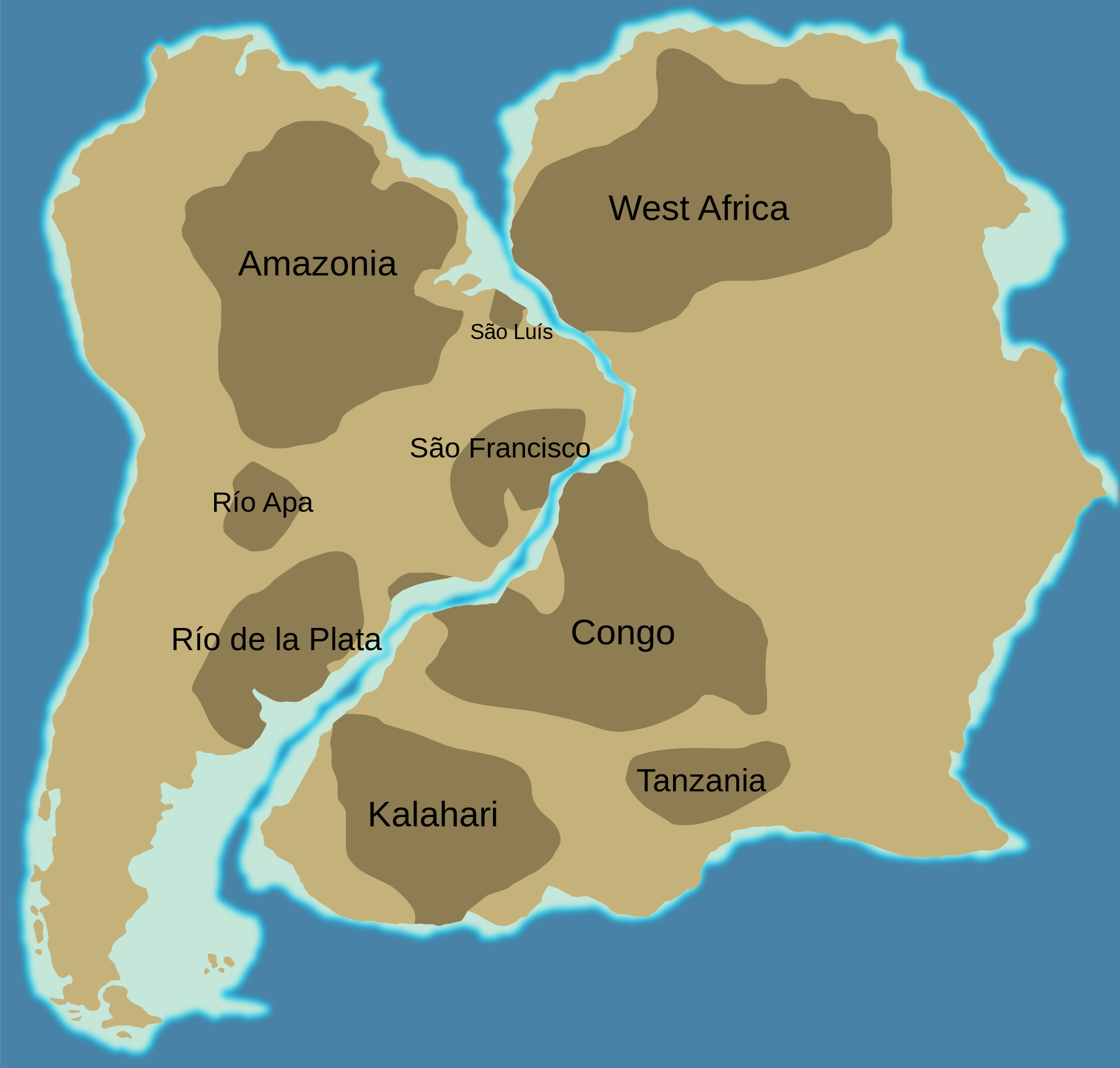
Below is an image of the African and South American Continents, showing the location of cratonic rocks of PreCambrian age. What does that mean? First, let's talk about the Geologic Time Scale. This is a timeline of events that have occured on Earth since it's formation. Just like our calendar is divided into days, weeks, months, and years, the Geologic Time Scale is similarly subdivided into Eons, Eras, Periods, and Epochs. The PreCambrian is an Era that extends from the formation of our planet to the formation of shelled animals (about 541 million years ago). It is during this time that land began to emerge out of the oceans, and plate tectonics began (see Origins: The Beginnings of Plate Tectonics).
Thus, the PreCambrian rocks shown on the map below formed around 2.1 billion years ago when several tectonic plates collided. As Pangaea began to break apart 200 million years ago, these rocks were separated by the newly formed rift zone which would eventually form the Atlantic Ocean. Today, these rocks are separated by an ocean, but we can use knowledge of how they formed to put the pieces of the puzzle back together.

Image from "Cratons West Gondwan" by Woudloper is licensed under CC BY-SA 3.0
Wegener believed that Pangaea came together as one large continent and formed a huge mountain range - as tall as or taller than the Himalayas today - and then broke apart sometime later along the same area where it had once come together.
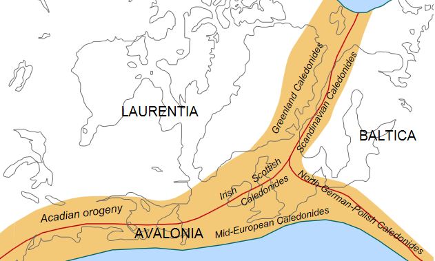
The image below shows this process. Between 490–390 million years ago (the Ordovician to Early Devonian periods), subduction caused the closure of the Iapetus Ocean and the collision of three tectonic plates. In this scenario, ocean-continent subduction changes to continent-continent collision (see Plate Tectonics: Convergent Plate Boundaries). As in #2 (Geologic Fit) above, this formed a mountain collision belt (orange areas on the map) with the most intense heat and pressures - the highest degree of metamorphism - at the center (red lines on the map). Not only can we use the pattern of rock formations such as cratons to help us understand tectonic events, we can use our understanding of how these events occur to determine the tectonic history of the area.

Image source: "Caledonides DE" by Kopiersperre is licensed under CC BY-SA 1.0
Scientists had long puzzled over how evidence of glaciers could be found in areas like South Africa and Australia which are today very hot. When the continents are put together, one can see how the Antarctic Ice Sheet extends north into South America, South Africa, India, and Australia. As Pangaea broke up, the ice sheets melted, leaving behind the evidence that they were once there.
Like Suess and others before him, Wegener noted the similarities between fossils now located on continents far apart. But it was more than this. He also noted that the fossils were of organisms from environments considerably different from what they are like today. This realization that the fossils not only match across continents but also are in different climatic areas indicated that the paleoclimates (past climates) could be mapped across Pangaea as well.

Ideas that are a radical departure from the norm are not usually well accepted. Wegener's ideas were largely ridiculed by the scientific community at large. The largest hurdle he had to overcome was getting people to accept that the continents moved. He, himself, had problems with this. He speculated the following mechanisms:
His ideas were so controversial that he had a hard time getting a professorship at universities. This did not stop him from continuing this and other research.
In 1930 he headed to Greenland for his fourth expedition, where he died at the age of 50.
"Wegener probably would have been part of the plate-tectonics revolution, if not the actual instigator, had he lived longer.“ (Dr. Peter R. Vogt)
Visit the Alfred Wegener Institute to learn more.
This is an animation showing plate motion from 200 Ma to Today by CR Scotese based on our current understanding of how tectonics works. Wegener was not far off! As you watch, note the following:
This second animation shows the possible plate motion of California 100 million years into the future! As you watch, note the following:
copyright Sonjia Leyva 2022 |
|