Storms
Tropical Cyclones / Hurricanes
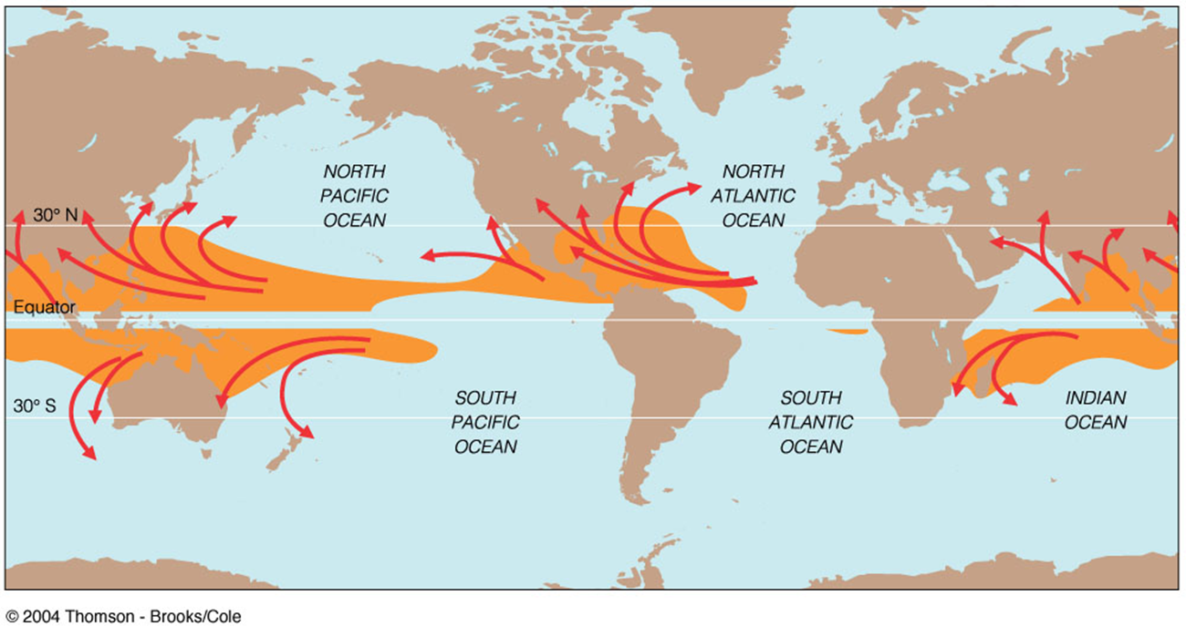
- Tropical cyclones are great masses of warm, moist air that form in the tropics. Their goal is to move excess heat out of the tropics. They occur in all tropical oceans except for the South Atlantic - although guess what happened in 2006?
- North Atlantic and eastern Pacific = hurricanes
- Western Pacific = typhoons
- Indian ocean = tropical cyclones
- willi-willi (aboriginal name) or typhoons
How a Hurricane Works
- Tropical disturbance -A low pressure zone develops and draws in clusters of thunderstorms and winds
- Tropical depression
- Surface winds strengthen, move about the center of the storm
- Central core funnels warm moist air up towards stratosphere
- Air cools, vapor condenses, latent heat released
- Fuels more updrafts, cycle repeats, storm grows
- Tropical Storm
- Storm has sustained surface wind speeds of +39 mph
- Hurricane
- Surface winds consistently over 74 mph = the eye forms
- The Eye
- Central portion of the storm
- As wind speed increases, winds are spiraled upwards prior to reaching the center
- A distinctive clear “eye” is formed
- Used as the threshold of hurricane status
- Strongest winds are located on the walls of the eye
- Hurricane Origins
All tropical cyclones form in the tropics between ~ 5° and 20 ° latitude. They cannot form at the equator (Coriolis effect = 0).
Hurricane Damages
- Wind
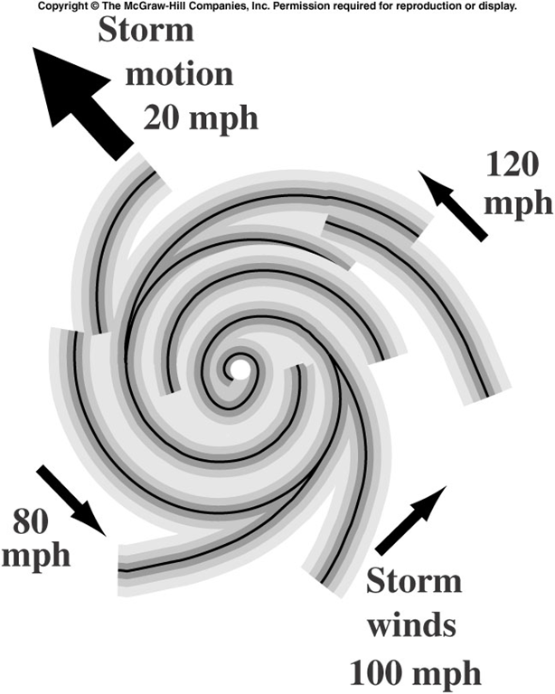
The wind speed that affects an area varies depending upon which side of the hurricane you’re on. Air moves counterclockwise around the center of the storm. Winds at the front of the storm are moving perpendicular to the direction of the storm movement and are therefore the weakest; Winds on the left side are moving in the opposite direction are reduced in speed as a result; winds on the back side of the storm are starting to move in the same direction of the storm and are slightly amplified; while winds on the right side of the storm are moving in the same direction as the storm and therefore are amplified and are the fastest. Thus, the amount of damage on the coastline will vary accordingly.
- Heavy Rains
- Mudflows and Debris Avalanches
- Flooding
Hurricane paths
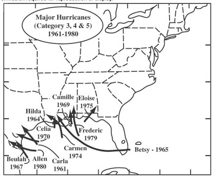
The storms that affect the east coast of the U.S. form off the coast of western Africa in the Sahel region. They head west across the Atlantic Ocean, pushed along by the Trade winds. The Coriolis Effect curves their path to the north. Whether or not their path moves into the Gulf of Mexico or the East Coast depends on the position and strength of the Bermuda High. If it is strong or more southerly, the hurricanes will go into the Gulf. If it is less strong or more northerly, then they will head towards the East Coast. This is pattern occurs roughly every ten years or so.
Most hurricanes that form in the eastern Pacific Ocean typically head straight towards Hawai'i (who wouldn't?). However, if conditions are right, they can head up the coast of Baja and make landfall there. Conditions needed for this to occur is warmer than normal water temperatures, which usually occur during El Niño events. The Southern California area has been hit once by a hurricane and possibly two other times due to these abnormal conditions:
- 1858 San Diego Hurricane
- The 1930s brought several tropical storms to the area, one of which may have been a hurricane.
- Hurricane Linda in 1997 was forecast to make landfall in So Cal, but moved offshore before doing so.
 |
 |
Case Studies
-
Hurricane Katrina - Katrina started out as a tropical storm in late August 2005 and quickly became a category 1 hurricane before making landfall in Florida on August 25-26. It weakened briefly upon entering the Gulf of Mexico, then strengthened to a category 5 in the warmer-than-normal Gulf waters on August 28th. Katrina made landfall 35 miles east of New Orleans near the Louisiana/Alabama border at 6 am in the morning on August 29th as a Category 3 storm with 127 mph winds.
- Lack of electricity / power
- Lack of telecommunications
- Lack of clean water
- Lack of food / water / clothing / medicine
- Lack of health care
- Lack of employment
- Shelter compromised
- Access to personal funds compromised
- Increased “critter” activity (snakes, alligators)
- Highest winds: 115 mph (185 km/h)
- Lowest pressure: 940 mbar (record!)
- Fatalities: 148 direct, 138 indirect
- deadliest hurricane of the 2012 season
- Damage: ≥ $68 billion (2012 USD)
(Second-costliest hurricane in US history) - largest diameter ever measured - 1,100 miles.
- Areas affected: Greater Antilles, Bahamas, most of the eastern United States (especially the coastal Mid-Atlantic States), Bermuda, eastern Canada
- DailyMail.com - Swept away by Sandy
- CNN.com - Hurricane Sandy Fast Facts
- theatlantic.com - Hurricane Sandy: After Landfall

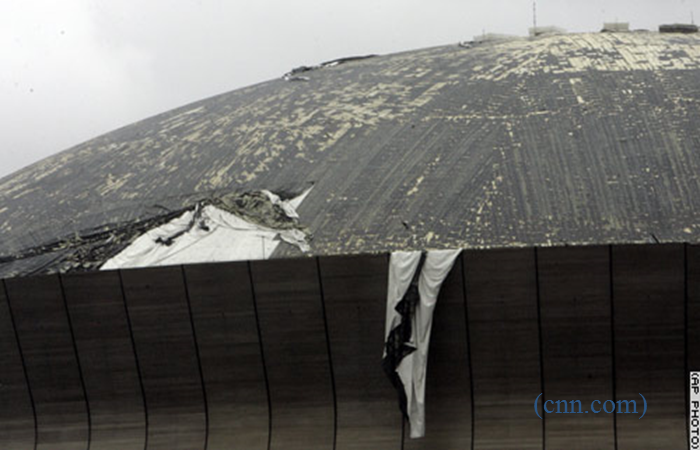
Emergency Shelter - Despite having several day's notice that the hurricane would hit New Orleans, not everyone could evacuate. This was due to many reasons, ranging from lack of money to take any form of transportation out of the area to physically unable to leave (like people in nursing homes or hospitals). Over 10,000 people took shelter in the Louisiana Superdome as a result. The problem was the Superdome really wasn't designed to function as an emergency shelter, so there was a lack of emergency supplies and bathroom maintenance. In addition, the roof of the Superdome began to fail under the strength of Katrina's winds.
 |
 |
Storm Surge, Winds & Urban Flooding - Much of New Orleans is below sea level. The storm surge was 20+ feet (6 m) at Louisiana / Mississippi border and 10 feet (3 m) at Mobile Bay, Alabama. The bowl-like configuration of the region meant that, when Hurricane Katrina struck, all of the water from the rain and storm surge flooded the area and stayed for many days longer than it would have in other areas. The storm surge not only flooded areas, but the force of the water moved items like casino barges, freight cars and bridges far inland.
High winds knocked down trees, power lines and homes. Areas that were not affected by flooding had to contend with debris littering the streets. In both cases, floodwaters and debris-filled streets made rescue efforts incredibly difficult.
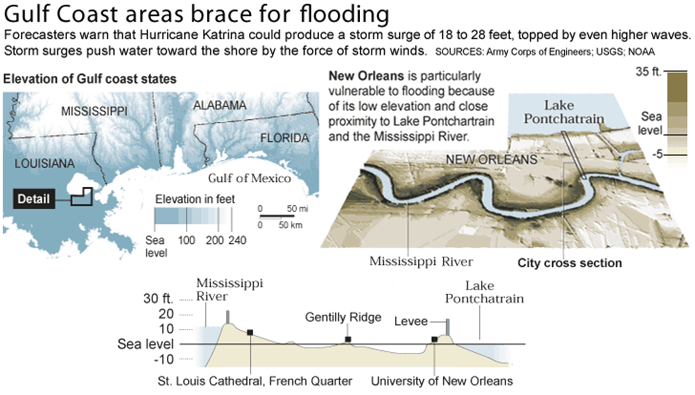
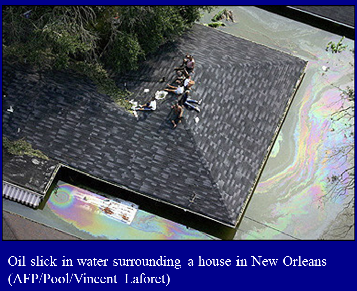
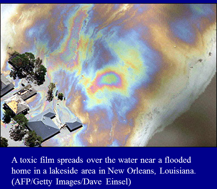
Urban flooding is a particularly dangerous problem. The heavy rains and storm surge produced by Katrina was exacerbated by the breeching of two levees. After Katrina had passed and moved north, the residents of New Orleans and the Gulf states had to deal with 90° F temperatures, high humidity, a lack of resources and urban flooding. Getting around was nearly impossible. Many people were left stranded on their roofs in the hot sun with little to no shelter. Getting into the water was dangerous: oil, sewage and other contaminants floated in the water, in addition to debris and marine life such as fish, sharks, and alligators where now swimming in the urban floodwaters.
 |
 |
Indirect effects of Katrina
Hurricane Mitch - In October 1998, a tropical storm that would become Hurricane Mitch formed in the Caribbean Sea. Within 36 hours it was a hurricane and headed for Central America. Mitch stalled off the Honduras & Nicaragua coast, unleashing 25-75” of rain over three days. The resulting floods devastated the countries of Honduras and Nicaragua, destroying crops, homes, businesses and infrastructure.
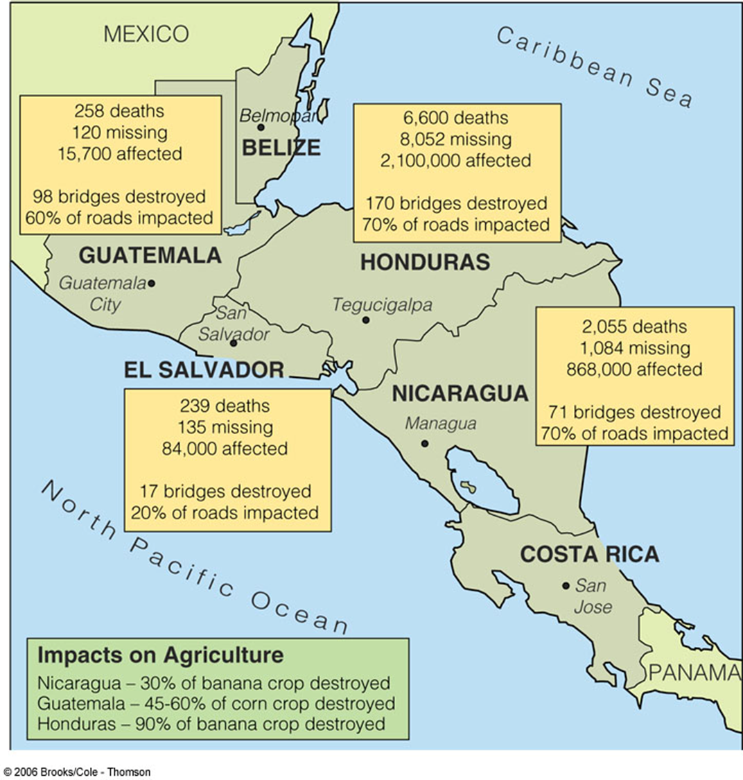
| Nicaragua: 3800 people killed 2000 killed when a crater lake overflowed and created a lahar |
Honduras: 6500 people killed 20% of population left homeless 60% of roads unusable 70% of crops destroyed |
| 15 day total: 11,000 people died Second deadliest hurricane on record |
|
Hurricane / Superstorm Sandy - Hurricane Sandy set quite a few records during it's brief existence.
Hurricane Sandy affected 24 states in the U.S., but New York & New Jersey were the hardest hit. The storm surge hit New York City on October 29 and flooded streets, tunnels and subway lines, and cut power in and around the city.
Reduction of Hurricane Damages

image source: Morning Star Builders

image source: NOLA - Is your house hurricane-season ready?
<< back |
||
