Storms
Air Masses
Storms are regional atmospheric disturbances. Storms have high winds and most have precipitation. Tropical cyclones occur in tropical regions. These storms can cause millions of dollars worth of damage and endanger life. Extratropical cyclones occur in Ferrel cells, and are winter weather disturbances. These storms can also cause extensive damage. Both types of storms are cyclones, or rotating masses of low-pressure air.
Air Masses
Air masses are a large body of air with nearly uniform temperature, humidity and density throughout. Air passing over land or water will take on the characteristics of the surface below it. These air masses can move within or between circulation cells. Different air masses do not mix! When two air masses meet, they form boundaries called “fronts”. Air masses can move within or between circulation cells.
 |
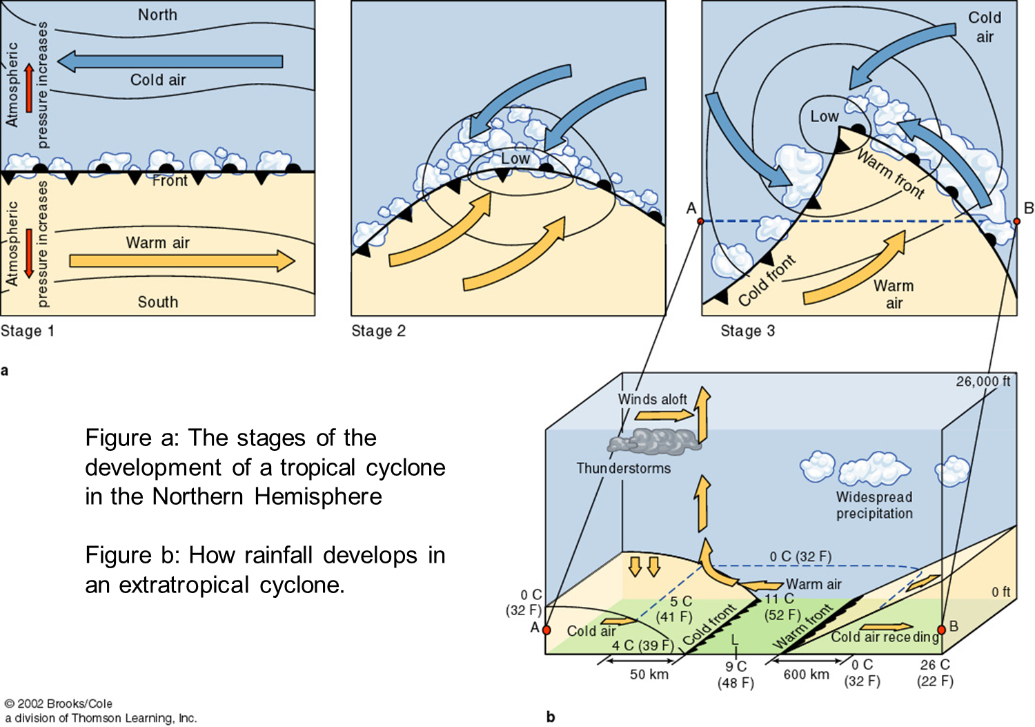
| Cold fronts are formed when cold air moves into an area. The cold air moves beneath the warm air mass, moving it upwards. The warm air is quickly uplifted, where it expands, cools and condenses to form thick clouds, thunderstorms. |
 |
| Warm fronts form when warm air moves into an area. The warm air moves over a cooler air mass. The warm air is gently uplifted, where it expands, cools and condenses to form low clouds, and light precipitation |
Cyclones and Anticyclones
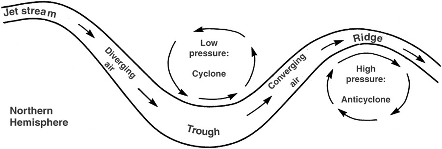
Bends in the polar jet create troughs and ridges. When two fluid media are moving in different directions near one another, turbulence forms between them. The air will start to rotate in a counterclockwise direction as air moves down and then up in the trough of the jet stream, which will form a cyclone. The air will start to move in a clockwise direction as the air moves up and over a ridge in the jet stream, which will form an anticyclone.

Cyclones - form a low pressure zone in polar jet trough. Winds at surface flow counterclockwise towards the core, where the air is updrafted. The air then expands, cools and condenses to form clouds, precipitation, and upper level outflow of air. |
 |
Anticyclones - forms a high pressure zone at ridge of polar jet. Air converges in upper atmosphere and begins to descend towards the ground. As it does it compresses, heats up and dries out. The air them flows outward at surface and creates dry, windy conditions. |
 |
Extratropical Cyclones
-
Extratropical Cyclones form at the boundary between the polar cell and its Ferrel cell (aka the polar front). Extratropical cyclones occur mainly in the winter when temperature and density differences are the most pronounced. They form when cold polar winds are moving to the east, and warm air from the Ferrell cell moving to the west. This forms zones of alternating high and low atm pressure “bends” the front into a series of waves. A twist will form along the front. Cold, dense air will slide beneath the warmer, lighter air, which rises upward to form clouds and rain.

Tropical Cyclones / Hurricanes
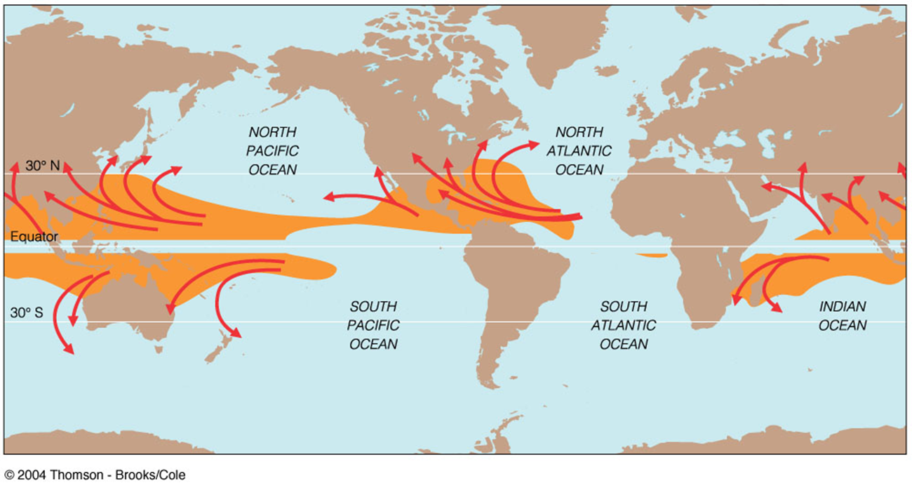
- Tropical cyclones are great masses of warm, moist air that form in the tropics. Their goal is to move excess heat out of the tropics. They occur in all tropical oceans except for the South Atlantic - although guess what happened in 2006?
- North Atlantic and eastern Pacific = hurricanes
- Western Pacific = typhoons
- Indian ocean = tropical cyclones
- willi-willi (aboriginal name) or typhoons
How a Hurricane Works
- Tropical disturbance -A low pressure zone develops and draws in clusters of thunderstorms and winds
- Tropical depression
- Surface winds strengthen, move about the center of the storm
- Central core funnels warm moist air up towards stratosphere
- Air cools, vapor condenses, latent heat released
- Fuels more updrafts, cycle repeats, storm grows
- Tropical Storm
- Storm has sustained surface wind speeds of +39 mph
- Hurricane
- Surface winds consistently over 74 mph = the eye forms
- The Eye
- Central portion of the storm
- As wind speed increases, winds are spiraled upwards prior to reaching the center
- A distinctive clear “eye” is formed
- Used as the threshold of hurricane status>
- Strongest winds are located on the walls of the eye
- Hurricane Origins
- 1858 San Diego Hurricane
- The 1930s brought several tropical storms to the area, one of which may have been a hurricane.
- Hurricane Linda in 1997 was forecast to make landfall in So Cal, but moved offshore before doing so.
All tropical cyclones form in the tropics between ~ 5° and 20 ° latitude. They cannot form at the equator (Coriolis effect = 0).

The storms that affect the east coast of the U.S. form off the coast of western Africa in the Sahel region. They head west across the Atlantic Ocean, pushed along by the Trade winds. The Coriolis Effect curves their path to the north. Whether or not their path moves into the Gulf of Mexico or the East Coast depends on the position and strength of the Bermuda High. If it is strong or more southerly, the hurricanes will go into the Gulf. If it is less strong or more northerly, then they will head towards the East Coast. This is pattern occurs roughly every ten years or so.
Most hurricanes that form in the eastern Pacific Ocean typically head straight towards Hawai'i (who wouldn't?). However, if conditions are right, they can head up the coast of Baja and make landfall there. Conditions needed for this to occur is warmer than normal water temperatures, which usually occur during El Niño events. The Southern California area has been hit once by a hurricane and possibly two other times due to these abnormal conditions:
<< Back |
||
