Sand Sources and Beach Supply
Beach sediments are derived from the surrounding areas, but how do they get to the beach? There are several ways this can happen:
- Rivers and Streams
- Eroding beach cliffs - 5 - 10% of beach sand
- Sand from the seafloor immediately offshore
- Flood control dams - They have virtually eliminated the sand supply to S. California beaches. The Ventura River sand supply is reduced to 66% of normal
- Sand & Gravel Quarries - Southern California has 77 sand and gravel quarries in stream channels. An annual sand and gravel production of 20 million tons
- Paved river channels - reduces channel widening, eliminates sediment transport and hinders groundwater recharge.
- Seawalls and riprap - reduce cliff erosion and focus wave energy onto the beach
Control of Coastal Erosion
Development of human structures along the coastline have created the need/desire to protect these structures from coastal erosion. A variety of hard stabilization techniques are used to protect these areas. These methods are largely ineffective in solving beach erosion.
- Riprap - large resistant boulders are placed at the base of a sea cliff. Riprap should not be discontinuous as this can hasten erosion.
- Seawalls - These structures are build to protect cliffs. Instead, they will accelerate the erosion of adjacent property.

- Groins - are built to block the longshore drift

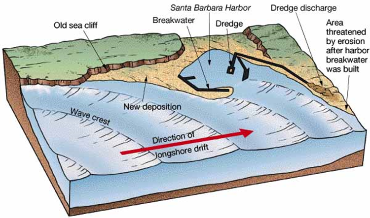
- Breakwaters - are built to reduce wave action on the coast. Unfortunately, sometimes they cause a build-up of sediment within the harbor. The Santa Barbara breakwater (below), for example, required continuous dredging (350,000 m3/yr) when it was in existence.

Responses to erosion problems
Alternatives to hard stabilization:
- Beach nourishment by adding sand to the beach system
- Relocating buildings away from beach
- Returning to “natural” channels. Example: The Los Angeles River is a fully lined reinforced concrete. The river was channelized after a devastating flood inundated LA and Orange counties in the early 1930s. It is designed to control high velocity flow. However, the concrete lining prevents scour and prevents sediments from reaching the coast.

The LA River in all it's channelized glory.

Map of the greater Los Angeles area with the LA and San Gabriel Rivers highlighted in red.
Recently, efforts have been made to return the Los Angeles River back to it's natural state. This idea was first met with skepticism. However, progress is being made and a large stretch of the river has been restored. The City of Los Angeles has a great website on the Los Angeles River Revitalization. The Friends of the Los Angeles River is another great site to learn more.

Photo of a revitalized section of the LA River near Marsh Park.
<< back |
||
