Tsunami Case Studies: 1940 - 1960
1946 - Eastern Aleutian Is., Alaska Tsunami
- April 1, 1946, 7.4 M
- 5 hours later the tsunami reached Hawaii
- Estimated maximum wave heights:
- 55 feet – Hawai’i
- 36 feet – O’ahu
- 33 feet – Maui
- 159 people died in Hawai’i
- May 22, 1960, 3:11PM
- Focus depth: 33 km (21 mi)
- Largest EQ ever recorded: 9.5 M
- Shaking lasted 10 minutes!
- 2000 deaths
- $550 million in damages (1960 USD)
 |
| A view of the tsunami generated in the Aleutian Islands striking the beachfront area at the Puumaile Tuberculosis Hospital on the Island of Hawaii. Photograph Credit: Mrs. Harry A. Simms, Sr. (source) |
 |
| This image shows the 1946 tsunami inundating Hilo, Hawaii. Note the man standing on the pier. He did not survive. The photograph was taken from the SS Brigham Victory, which was in the harbor at the time of the event. This disaster provided the impetus for the establishment of the Pacific Tsunami Warning Center in Ewa Beach, Hawaii. (source) |
1960 “Chilean tsunami”
| Facts:
|
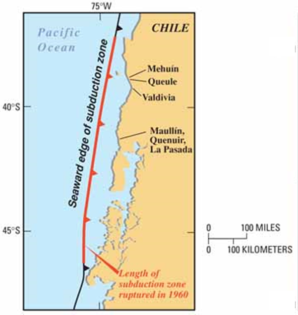 |
Damages in Chile
 |
| Many houses in Maullín, Chile, withstood the magnitude 9.5 Chile earthquake of May 22, 1960. The tsunami generated by the quake caused most of the damage shown in this photo, taken between May 23 and June 3, 1960.
(source) |
 |
| (mouse over image to see before/after) Though a mile from the sea, most of Queule, Chile, was overrun and washed away by the tsunami that followed the 1960 Chile earthquake. From the height of debris tangled in the branches of trees that remained standing after the 1960 tsunami, Wolfgang Weischet, then a geographer at the Universidad Austral de Chile in nearby Valdivia, estimated that water from the tsunami was as much as 13 feet deep in Queule. (source) |
Damages in Hilo, Hawaii
The first tsunami wave struck Hilo shortly after midnight local time. It was only a few feet high and many people returned to their homes, thinking the danger had passed. However, a second, larger wave struck just after 1 am, causing 61 deaths and 282 serious injuries.


Damages in Onagawa, Japan
The people of Japan are very familiar with tsunami. Early in the morning of May 23, 1960, Fireman Endo Fukuei noticed the ocean behaving oddly. He notified officials in Onagawa, who got the warning out. No one in Onagawa died as a result. They did, however, have a good time watching the waves roll into town. (source)

 |
 |
 |
 |
| Some residents gathered on a hillside as the first large wave poured into town. Almost 3 hours later, crowds remained on this hillside as another wave arrived (source). |
Damages in Crescent City, California
Crescent City, California was also hit hard by the Chilean tsunami. Unlike the residents of Chile, Hawai'i and Japan, the residents of Crescent City had no idea what a tsunami was or what to do. Still, they headed the official warnings and no lives were lost as a result. The town was flooded and damage was estimated to be around $30,000.
 |
| Waterfront area in Crescent City, California, flooded by the 1960 Chilean tsunami. Here, the tsunami caused more than $30,000 in damage, including the sinking of two boats. However, damage was much more severe 600 miles to the south in the Los Angeles area, where the tsunami killed one person and caused from $500,000 to $1,000,000 in damage, including the sinking of 30 boats. (source) |
Comparing the 1700 Cascadia Earthquake and the 1960 Chile Earthquake
"Both the 1960 Chile earthquake and the 1700 Cascadia earthquake were caused by sudden ruptures of long segments of subduction zones. Each of these quakes generated a tsunami that not only struck nearby coastal areas but also caused damage in coastal areas as far away as Japan." (source)

"As shown by wave heights observed in Japan, subduction-zone earthquakes in Chile and Cascadia have caused tsunamis that were large even after crossing the Pacific Ocean." (source)

"Long times between earthquakes can erase memories of how to survive their tsunamis. The region of the 1960 Chile earthquake had gone without such a quake since 1837. Except for Native American legends, memory of the 1700 Cascadia earthquake is limited to written records of its tsunami in Japan." (source)

Scientists can use many clues to help determine if a tsunami has happened in the past. One such tool is to observe sand deposits and old soil horizons (called paleosols). In both pictures below, the soil is overlain by a sandy layer, which was then covered by muds. This can be interpreted as sand coming in with the tsunami wave(s) and depositing on top of the soil. Then mud was deposited by the resulting flood waters left by the tsunami.


<< back |
|
next >> |
copyright Sonjia Leyva 2015 |
||