Tsunami Case Studies: 1964, 1979 & 1992
1964 - “Good Friday” or “Great Alaska” earthquake
- March 27, 1964
- Moment Magnitude = 9.2
- Ritcher Magnitude = 8.4
Reported tsunami:
- Valdez, Whittier, Seward, Kodiak, and other Alaskan Communities
- British Columbia, Oregon, California, Hawaii and Japan
- Tsunami Related Fatalities
- Alaska = 106
- British Columbia = 0
- Washington = 0
- Oregon = 4
- California = 12
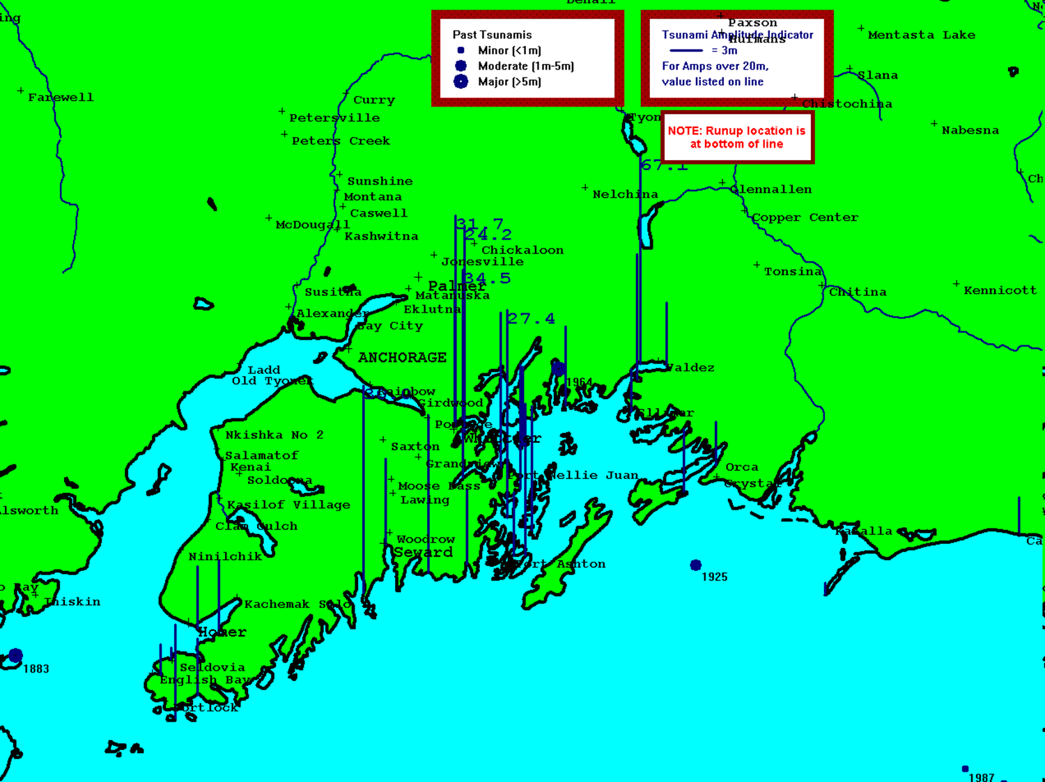
Tusnami are particularly dangerous when they affect nearby communities. Below is a run-up map of the Anchorage, Alaska region for the 1964 tsunami. "Run-up" refers to how far inland the tsunami travels; this is a function of how high the waves are and how flat the land is. Flatter areas had larger run-ups than steeper ones.

"Aerial image for larger view of Valdez, Alaska, showing the extent of inundation along the coastline following the tsunami generated by an earthquake on March 27, 1964. A slice of the delta, approximately 1,220 m long and 183 m wide, slid into the sea and carried the dock area and portions of the town with it. Credit Dept. of Interior."(source)
Damages - Crescent City, CA
The first experience the residents of Crescent City, California, had with a tsunami was in 1946. The wave generated by the 1964 EQ was larger (6.1 m), and destroyed 30 blocks, caused 12 deaths and did $27 million in damage


"Aerial view of Crescent City, California, after the tsunami accompanying the 1964 Good Friday Earthquake in southern Alaska. Harbor is toward the viewer. Photo courtesy of Lori Dengler, Humboldt State University (source)"
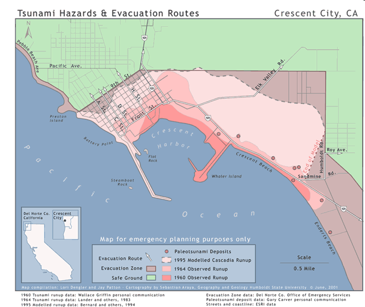
Crescent City - like may other coastal communities - has created a tsunami evacuation plan. These plans include historic and potential tsunami run-ups. Maps such as these aid emergency planners to determine where hazard areas are and plan evacuation routes.
Other Crescent City Tsuanmi
- 7.0 M earthquake located 90 miles offshore
- Entire city evacuated in 20 minutes No waves reported.
- 8.3 M earthquake in the Kuril Islands (near Japan)
- 5 – 6 foot waves reported.
1979 - The French Riviera
On October 16, 1979 a submarine landslide generated a local tsunami that affected part of the Nice international airport and the local coastline. The sea retreated 975 feet before rushing back in the form of two 32-foot-high waves. The number of reported deaths vary depending on the source, but range from 6 to 23.
The maps below show the region affected by the tsunami. There appears to be no consensus as to the cause of the landslide OR the tsunami, but the coastline from Nice to Antibes - La Salis was affected by coastal flooding associated with the tsunami.

1992 Nicaraguan Earthquake
On September 2, 1992, a magnitude 7.7 earthquake struck off the coast of Nicaragua. Several tsunami waves were generated, with heights ranging from 3 to 10 meters. The number of deaths vary, but most sources agree that it was at least 116 people killed, 68+ missing and over 13,500 were left homeless. Most of these deaths were children.
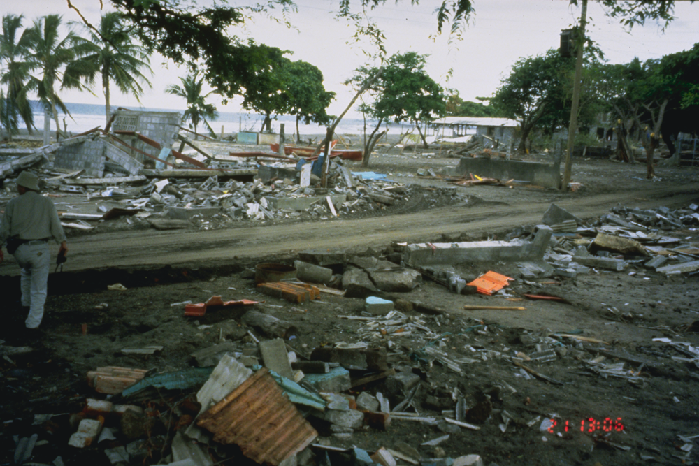 |
| "The tsunami damage at El Tranisto, (population 1,000), the area most devastated by the tsunami in Nicaragua. Sixteen people were killed (14 children and two elderly men) and 151 were injured. More than two hundred houses (nearly all the houses in El Tranisto) were destroyed by waves that reached more than nine meters at this site. It is thought that the first wave was relatively small, and that it provided a warning which allowed most of the able-bodied people to escape the force of the second and third very destructive waves. Photo Credit: Harry Yeh, University of Washington. " (source) |
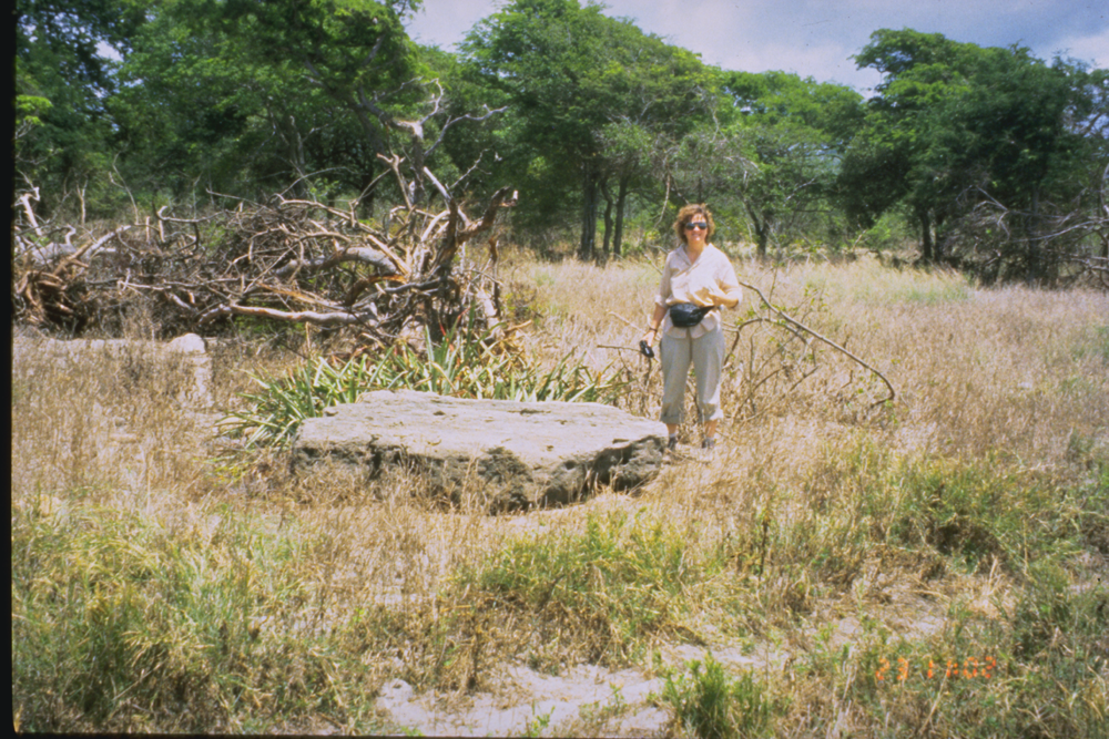 |
| "The beach area at El Popoyo after the tsunami. A large rock shown in the photo was carried from an offshore region 50 m inland and raised 1.85 m above sea level. The rock measured 2.3 m by 1.6 m by 0.5 m thick and provides a silent testimony of the force of the waves at this location. Photo Credit: Harry Yeh, University of Washington." (source) |
 |
| "This slide shows a typical sight at El Popoyo. Two very different structures remain intact. The one on the right is a rigid, sturdy structure. The structure on the left is a very weak structure but is elevated high off the ground. Photo Credit: Harry Yeh, University of Washington." (source) |