Tsunami Case Studies: 2004, 2010, & 2011
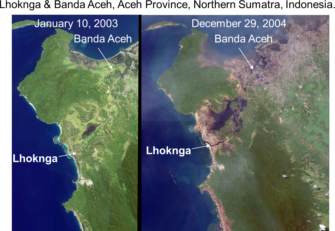
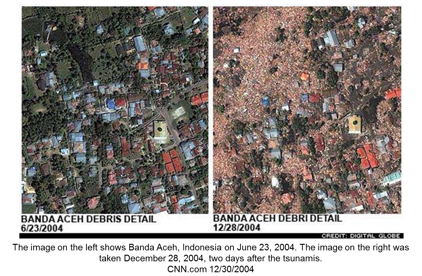
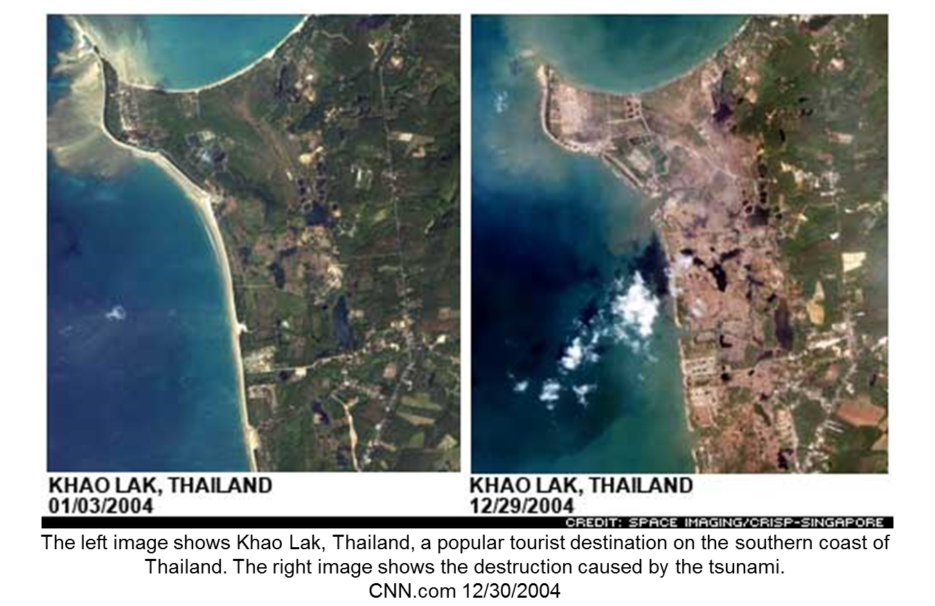
2004 - Sumatra Earthquake
On Sunday, December 26, 2004 at 7:58 AM, subduction of the India plate beneath the overriding Burma plate (megathrust) generated a 9.0 M earthquake just off the Indonesian island of Sumatra. An estimated 1500 km of the fault ruptured, the largest ever recorded, with ~15 m of horizontal displacement and ~10 m of vertical displacement.
Unlike the Pacific Ocean, there was no warning center in the Indian Ocean. Seismologist at the Pacific Tsunami Warning Center in Hawaii first registered the earthquake but, due to lack of any tsunami sensor networks in that region, was unable to know if a tsunami had formed. The size of the earthquake suggested that it had likely generated a tsunami but had no way of warning the people in the nearby countries. Hundreds of thousands of people lost their lives because of the lack of a warning system in the Indian Ocean.
The tsunami killed approximately 230,000 people in 14 countries. Infrastructure in Sumatra and other areas were heavily damaged or destroyed, including roads, rails, and other means of transportation, communication lines, water supplies, sewer lines, housing, crops, and herds.
Animation of the giant 2004 earthquake rupture propagation (QuickTime)
Countries affected by the 2004 Sumatra Tsunami


2010 - Chilean Earthquake
The Chile-Peru Trench is still an active subduction zone, capable of producing large, devistating earthquakes. On Saturday, February 27, 2010 at 03:34:14 AM a magnitute 8.8 earthquake struck in the same area as the 1960 earthquake. A large tsunami was also generated, causing damage throughout the Pacific Ocean.

2011 - Honshu, Japan Earthquake
On Friday, March 11, 2011 at 02:46:23 PM a magnitude 9.0 earthquake shook the Honshu area of Japan for 4 minutes. The earthquake was a result of thrust faulting on or near the subduction zone plate boundary between the Pacific and North America plates. Computer modeling indicates that the fault moved upwards of 30-40 m, and slipped over an area ~300 km long by 150 km wide. The earthquake triggered a large tsunami.
Tsunami heights reached 30 meters and inundated 433,000 kilometers of Land. (UN OCHA). The people of Japan are used to earthquakes and their resulting tsunami so they knew what to do when the shaking stopped. They have no way of knowing how high the waves will be, however. In many places the tsunami waves simply went over the seawalls designed to stop the tsunami and inundated coastal communities, washing entire villages out to sea.
- Satellite Photos of Japan, Before and After the Quake and Tsunami
- Narrated animation of March 11, 2011 Honshu, Japan tsunami propagation
- Just the facts:
- 12,344 Casualties
- 492,00 Evacuated
- 15,000 Confirmed Missing
- 138,000 Houses and Buildings Damaged
- 17,000 Houses and Buildings Destroyed
- $309bn in Damages
- 15-18 Million Tons of Debris in Miyagi Prefecture
- Nuclear Reactors Heavily Damaged
 |
| Houses in Natori were caught as a wall of water up to 10m (33ft) high in some places swept inland. (BBC) |
 |
| Damage to gas pipes and electricity lines meant many fires broke out in the aftermath of the quake, including in Natori City.(BBC) |
 |
| In Ichihara giant fireballs rise from a burning oil refinery. Thousands of people have also been evacuated from the area around a nuclear power plant, over fears its cooling system was damaged.(BBC) |