
Volcanic Hazards: Pyroclastic materials
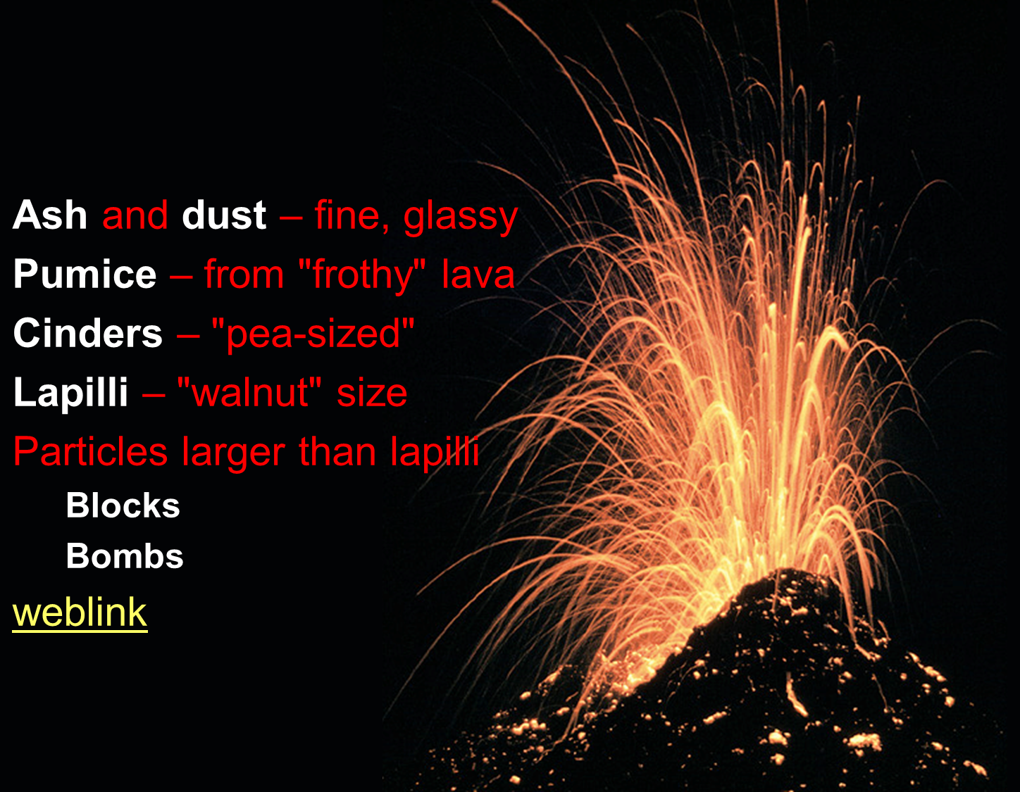
Tephra - – pyroclastic debris deposits.
- Tuff – Lithified ash with or without lapilli.
- Air-fall tuff – Accumulations of ash that fall like snow.
- Welded tuff (ignimbrite) – Tuff that is deposited while hot.
Ashfall- The amount of ash is dependent upon three factors:
- Distance from vent

- Type of eruption
- Size of eruption

Damage to urban areas can be enormous
- Crops are destroyed threatening the food supply
- Public water contaminated
- Buildings collapse under weight of ash
- Air travel disrupted
Eruptions / Explosions
Lassen Peak, California- Elevation: 10,457 ft (3,187 m)
- Last Eruption: 1914 - 1917
- Type: Lava dome, formed after Mt. Tehama became extinct & eroded away. Lassen Peak is a part of the Lassen dome field
- Volcanic arc/belt : Cascade Volcanic Arc
- 1914-17 eruption: Lassen began erupting May 1914. On July 18, 1914 – Huge ash cloud ejected 3,350 m into atmosphere. After nearly a year of being quiet, lava oozed out of crater from May 16 – 18, 1915, followed by an avalanche of hot rocks combined with snow and triggered a lahar that extended more than 50 km on May 19. Eruptions continued through 1917, then ceased.
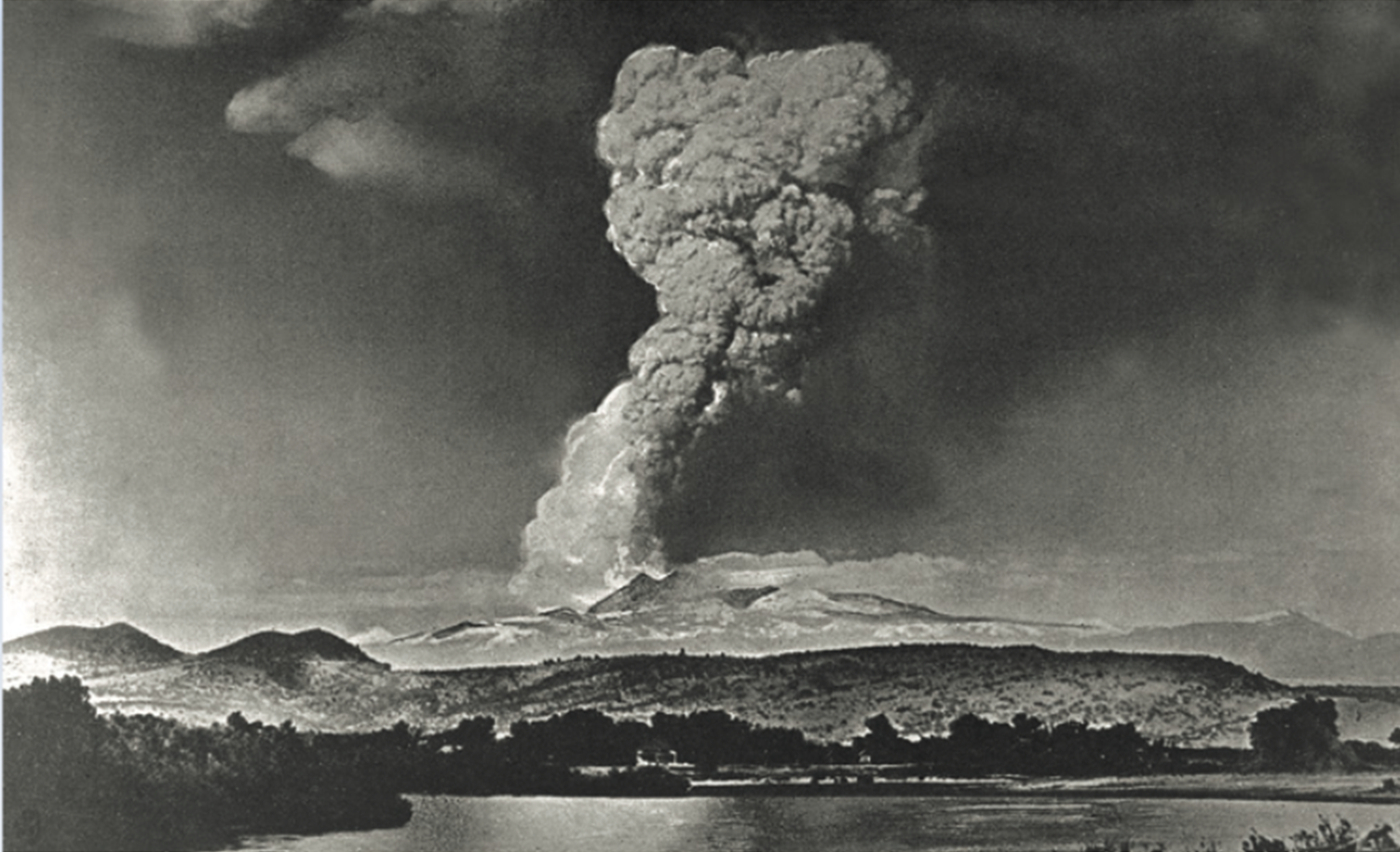
Lassen Peak in northern California produced a series of eruptions during 1914–17. The largest of those eruptions, on May 22, 1915, blasted rock fragments and pumice high into the air and rained fine volcanic ash as far away as Elko, Nevada, 280 miles (450 km) to the east. This photograph, taken from the town of Red Bluff, 40 miles (65 km) west of the volcano, shows the huge eruption column of ash and gas, which rose to a height of more than 30,000 feet (9,000 m). (Photograph by R.E. Stinson; courtesy of the National Park Service.)(source)
Pyroclastic Flows / Nuée Ardentes
Nuée Ardentes are a fiery pyroclastic flow made of hot gases infused with ash. They can flow down sides of a volcano at speeds up to 200 km per hour & 800º C.
Mount Saint Helens, Washington- Elevation: 8,365 ft (2,550 m)
- Last Eruption: 2004 to 2008
- Type: stratovolcano
- Volcanic arc/belt: Cascade Volcanic Arc
1980 Eruption:
The blast was directed to the north, which was a good thing for the people in Portland to the south. The blast felled millions of trees, displaced Spirit Lake which caused a lahar to form, and formed an ash cloud that dropped ash over Washington, Oregon, and nearby states to the east.
While this was a large eruption, it was not as large as other eruptions. Volcanologists us the Volcanic Explosivity Index (VEI) to describe how large an eruption is. Below is a graphic showing how large the 1980 Mt. St. Helens eruption was compared to others. Mt. St. Helens is the small, yellow ball with a VEI of 4.
Now let's look at how some of these eruptions look on a map of the U.S. The amount of ash from Mt. St. Helens is puny next to that erupted from Yellowstone and the Long Valley Caldera.


Mount Shasta, California
- Elevation: 14,179 ft
- Last Eruption: 1786
- Type: stratovolcano
- Volcanic arc/belt: Cascade Volcanic Arc
- Second tallest in the Cascade Range
- Erupted 11 times over last 3,400 years, 3 times last 750
- The slopes of Mount Shasta are covered with pyroclastic flows such as lahars. An event 300,000 years ago deposited 8x amount of debris as did the Mt. St. Helens 1980 event.

Other Volcanoes Notorious for Producing Pyroclastic Flows:
- Mount Mayon, Philippines, 1968
- El Chichon, Mexico, 1982
- Mount Unzen, Japan, 1991
- Mont Pelee, 1902-1903, 1929-1932
- Mont Pelee, Martinique, 1902
- Krakatau, Indonesia, 1883
Lahars (mudflows)
How to make a lahar: Add water + volcanic material = lahar!
Water sources:
- Melt glaciers
- Displace lakes
- Rain
Kelud, Indonesia
- Last eruption: February 13, 2014
- Elevation: 5,679' (1,731 m)
- Type: Stratovolcano
- Volcanic arc/belt: Sunda Arc
- In 1586 and 1919, a large crater lake at summit of Kelud. Pyroclastic eruptions + water from lake triggered a lahar.
Mount St. Helens, Washington, 1980
Mudflow was caused by the displaced Spirit Lake during the 1980 eruption. The mudflow went 60 miles to the Columbia River, releasing 45 million cubic yards sediment into the river.
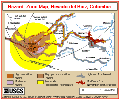
Nevado Del Ruiz, Colombia
Mount Rainier, Washington
- Last eruption: 1994
- Elevation: 17,425'
- Type: Stratovolcano
- Mountain range: Cordillera Central, Andes
- 1985 eruption: On November 13, 1985, at 9:08 pm the volcano erupted. Pyroclastic flowes melted the summit glaciers, generating a deadly lahar. The 50 feet deep mudflows traveled 30 mph in all directions from the summit, burying villages as they slept. The hardest hit was the town of Amero, 30 miles away, which was nearly completely burried by the lahar. Three quarters of the residents (21,000 people) of Amero were killed. In all, twenty-five thousand people were killed in the 1985 eruption.
Scientists and the public called for and got a warning system for the volcano. The volcano erupted again in 2008, but this time everyone was prepared. Villages and towns were evacuated, and lives were saved.
- Last eruption: November to December 1894
- Elevation: 14,411 ft
- Type: Stratovolcano
- Volcanic arc: Cascade Volcanic Arc
- Mount Rainier has a history of dangerous mudflows. The map below shows where lahars and debris flows have been mapped on the flanks of the volcanoes. Mudflows threaten the towns and villages blow this dangerous volcano, so threatened towns hold evacuation plans and drills to prepare for these hazards.


<< back |
||
| Professor Sonjia Leyva | |
| CSULA Department of Geosciences and the Environment | |
| Pasadena City College Department of Geology | |