
Introduction
Storms
Storms are regional atmospheric disturbances. Storms have high winds and most have precipitation.
Types of Storms
- Wind
- Thunderstorms, Snow / Rain storms
- Extratropical cyclones
- Tropical cyclones
Windstorms
Wind (Definition): a horizontal motion of air caused by differences in atmospheric pressure. Maximum pressure change is perpendicular to the pressure gradient.

Local / Regional Winds
Sea Breezes and Land Breezes
In the morning, the air over land warms quicker than that of the ocean
Warm air rises and cooler sea air moves in to form a sea breeze.
The process reverses in the evening The air over the land cools faster than that over the sea. Warmer air over the sea rises, and the cooler air over the land moves in to take its place. This breeze is called a land breeze

Mountain and Valley Breezes
These breezes are similar to the sea and land breezes. In the morning, the air in the mountain tops warms quicker than the air in the valleys. Warm air rises and the cooler valley air moves up the mountain slopes to form a valley breeze.
The process reverses in the evening The air on the mountain tops cools faster than that in the valleys. Warmer air in the valley rises, and the cooler air on the mountain tops moves downslope to take its place. This breeze is called a mountain breeze

Foehn winds
Foehn winds are a type of dry down-slope wind which occurs in the lee (downwind side) of a mountain range. These winds are often called “Rain-shadow” wind. Air rises up the sides of the mountain; as it does, the air cools, expands, and water vapor condenses to form clouds and sometimes precipitation. Then it goes up and over the mountains, and down the other side. As it does, the air compresses, heats up and dries out. Many of the world's deserts are formed this way (the Mojave, the Atacama Desert in Chile, and the Tibetan Plateau in Asia)

Katabatic winds
A katabatic wind carries high density air from a higher elevation down a slope under the force of gravity. Typically, these winds form when a high pressure system parks itself over a mountain range (say, the Rockies). Air flows down out of the high pressure system, compressing, heating up and drying out as it does. Then it flows down the mountain slopes, heating up and drying out even more. Then it crosses the desert, and heats up and dries out even more. Finally, it squeezes though the mountain passes in the Santa Susana, San Gabriel, and San Bernardino mountains. This causes the hot, dry air to speed up, and forms the Santa Ana Winds.
These Katabatic winds are common in other parts of the U.S. and world, each with their own name.

Monsoons
"Monsoon" is a pattern of wind circulation that changes with the season. The regions affected by this wind pattern usually have wet summers and dry winters. While many areas are affected by monsoons, India and SE Asia are the hardest hit.
The genesis for these winds is due to the different specific heats of land and water and the annual north-south movement of the intertropical convergence zone. During the winter, the ITCZ is mostly below the equator. Air blows off the Asian continent towards the Indian Ocean; somewhat like a land breeze on a ginormous scale. In summer the ITCZ moves north of the equator. As it does, the winds shift to blow towards the Asian continent and the Himalayas. This brings warm, humid air to India and SE Asia. The air cools, expands and condenses to form clouds and rain as the air moves up the slopes of the Himalayas. India receives anywhere from 50 - 90% of it's annual rainfall amount during the monsoon season. And how much is that? Around 200 - 300 mm (8 - 12 inches) during the three month monsoon season. Compare that to the 12 inches/year Southern California receives!

November 30th, 2011 Windstorm
- Recorded wind speeds: Henninger Flats, Calif. (2,800 ft., near Pasadena): 167 mph (unofficial)
- Hardest hit areas were:
Altadena, Arcadia, Covina, Duarte, El Monte, La Crescenta, Monrovia, Montebello, Rosemead, San Gabriel, and Temple City
Los Angeles (LAX Airport), Calif.: 47 mph
What caused these hurricane force winds? Not a hurricane! Instead, it was an extremely strong high pressure system just offshore of San Francisco next to an extremely strong low pressure system over Arizona. Air in a high pressure system flows clockwise while winds in a low pressure system move counterclockwise. This means that the air in each meets up in-between the two pressure systems and moves in the same direction - to the south in this case. This funneled all of the winds directly into the Southern California area.
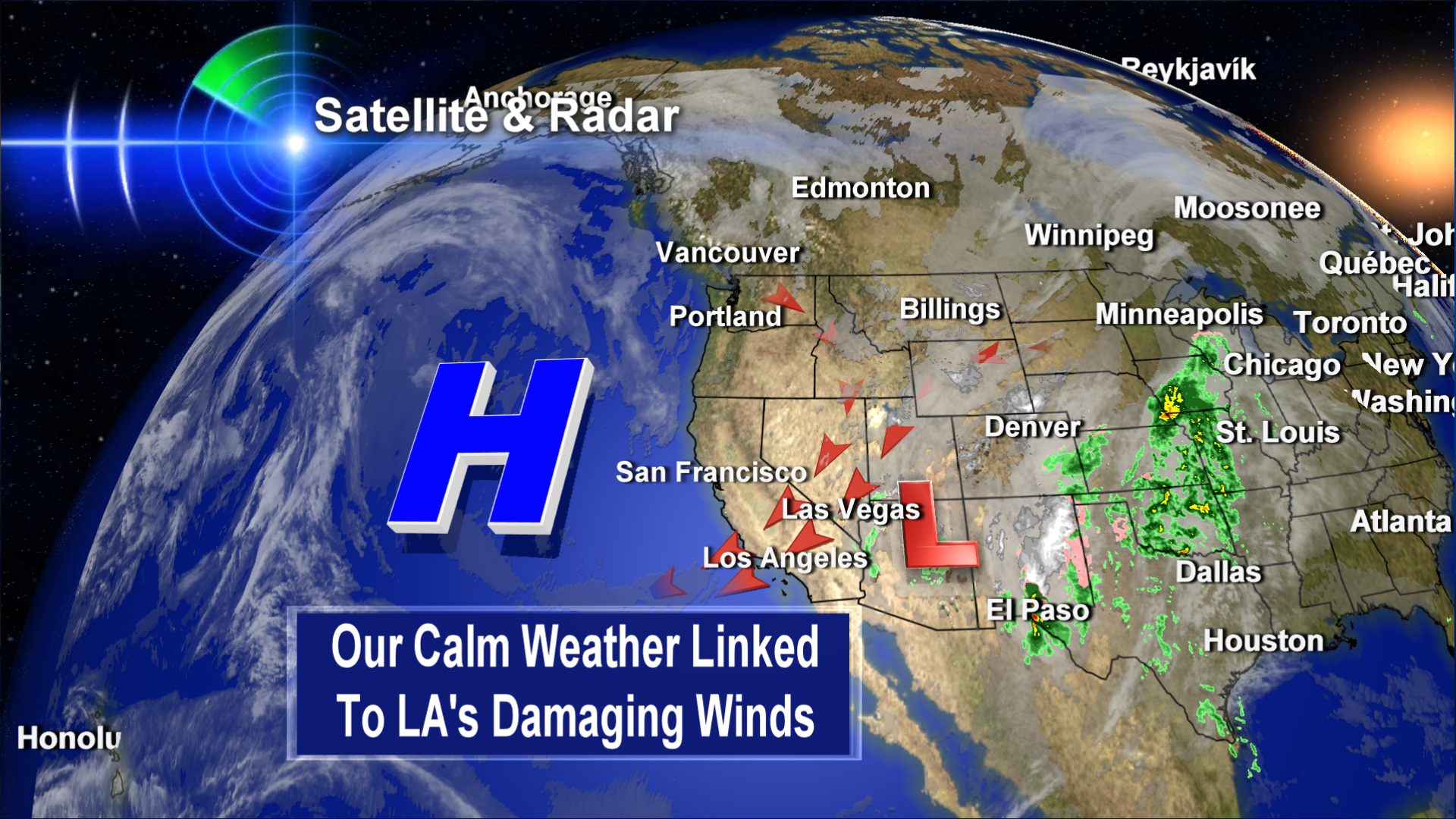
Image source: Bruce Sussman's Portland Weather Pages

The windstorm knocked out power to thousands of homes & businesses in the San Fernando and San Gabriel Valleys. Most had their power back on in one to two days. Others - like me - had damage to their home that had to be fixed first before power could be restored. As electricians and general contractors were now in high demand it took several days for many people to get power restored.
What My Family Learned:
We were without power for 10 days. Why??
Our neighbor's bush (the tree guy called it a bush - it was the size of a tree. Go figure!) to the north of us fell into our yard, taking out the fence, our aluminum awing, the riser on the roof and very nearly our Jeep Cherokee. The riser needed to connect power to house needed to be fixed first. This required an electrician to do so. Which took a while. So, for ten days, we had to deal with the problems associated with a lack of electricity:
- Food spoiled
lack of heat
lack of entertainment for kids . . .


Tree removal
The insurance company deemed storm “an act of God”, THEREFORE, limited liability. THEREFORE, neighbor not liable (despite the fact that the tree hand’t been cared for properly). Cost to remove tree? $1,000
However, there were many things our family did right, which made this whole adventure more bearable:
- Called insurance right away
- Took LOTS of pictures
- Neighbor to south let us run an extension cord from his house so we’d have power
- Old house = no Central Air/Heating = floor furnaces = still have heat!
- We have an old, rotary-dial non-electric phone, so we could still make and receive phone calls (good because it was hard to charge the cell phones!)
- EMERGENCY SUPPLIES meant that we had flashlights + batteries and other necessities already on-hand
<< HOME |
||