Thunderstorms
Thunderstorm Life Cycle
Developing stage
|
 |
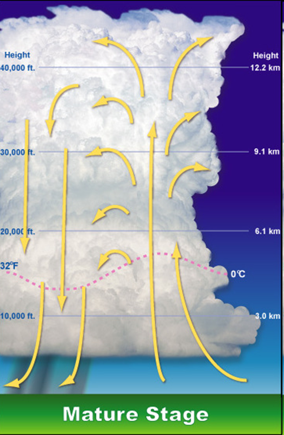
Mature stage
|
 |
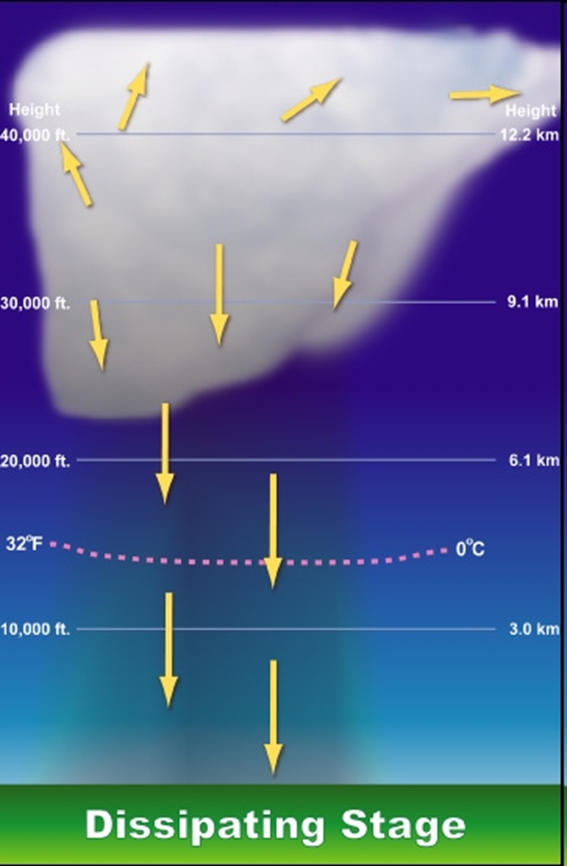
Dissipating stage
|
 |
Thunderstorm classification
- Single Cell – a single thunderstorm with one main updraft.
- Rear Flank Supercell - Low precipitation (LP)
- Classic (CL)
- Front Flank Supercell - High precipitation (HP)
Multicell cluster – clusters of storms, often form from updrafts near mountains.
Multicell line – when multicell clusters form a line.
Supercells - these are large, quasi-steady storms. The wind speed & direction vary with height and there are separate updrafts & downdrafts. These storms can produce tornadoes. Supercells are divided into three groups:
Thunderstorm Related Hazards
LightningLightning is an electrostatic discharge that suddenly occurs in a storm either inside a cloud (IC lightning), between clouds (CC lightning), or between the cloud and the ground (CG lightning).
There are many different types of lightning than the ones listed above. PBS's NOVA scienceNOW Lightning site has a nice description of the various lightning varieties.
Damaging winds
High-speed winds are frequently associated with thunderstorms. These winds include:
- Wind shear turbulence - these winds are caused by a change in the speed of wind at various altitudes or a change in the direction of wind at various altitudes.
Wind shear can be classified as either a micro or macro burst. Microbursts are small in size (outflow less than 2½ miles) with winds +168 mph. They can also be either wet or dry (see image below). Macrobursts, on the other hand, are larger with outflows greater than 2½ miles, but winds are slower (130 mph).
image source: National Weather Service Brownsville, TX
- Straight-line winds & gust fronts
Haboobs are dust storms that form from the downdrafts from thunderstorms. The leading edge is called a gust front.
Image source: What in the Wild, Wild World of Weather: Haboob by Shelly SitesHail
Hail forms when updrafts in a thunderstorm carry raindrops upward into the freezing levels of the atmosphere. The hail grows by collision with supercooled water drops. They will stay aloft in the stormcloud until they become too heavy and fall to the ground. Hail comes in many sizes, ranging from smaller than a pea to the size of a grapefruit (rare).
Tornadoes
Why do some thunderstorms spawn tornadoes while others do not? The truth is that scientist really don't know. Many damaging tornadoes can be spawned from Super Cell Thunderstorms, but regular thunderstorms and even hurricanes can form tornadoes, too.
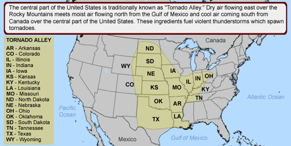
The Midwestern states of the U.S. are the tornado capital of the world due to the confluence of air that occurs in that region. Moist air from Gulf of Mexico meets up with fast moving cold, dry air mass from Canada. These two air masses don't play well with one another. Then the jet stream moving east at 150 mph shears off the tops of the developing thunderstorms. Warm moist Gulf air releases latent heat, creates strong updraft, which is sheared by polar air, then twisted in a different direction by jet stream. Then, voilá! A tornado!

This is actually an oversimplification of the process. There are many factors that determine if, when, and where a tornado will form and how strong it will be.
The strength of the tornado is measured on the Fujita-Pearson Scale. Although the two usually go hand-in-hand, the size of a tornado is not necessarily an indication of its intensity!
Time’s “10 Deadliest Tornadoes in U.S. History ”
Why don’t tornadoes strike large cities? Actually, they do. Tornadoes occur over large regions and cities are relatively small targets. Several times in the past tornadoes have struck large cities, with devastating results - Oklahoma City Tornado (1999) is but one.
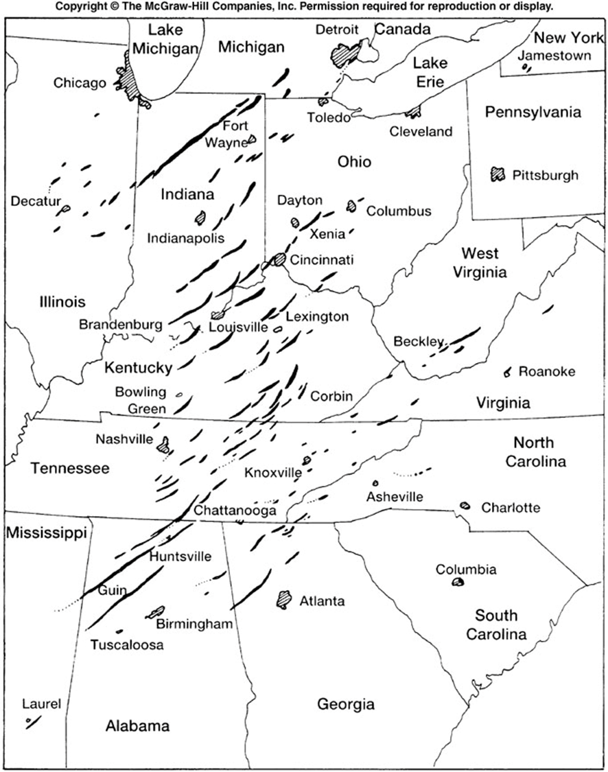
The Super Outbreak, 3-4 April 1974
In early April of 1974, 5 weather systems collided, Dry air from the SW overrode moist Gulf air, creating an inversion layer. The Gulf air pushed through the inversion layer, destabilizing the area, and thunderstorms developed. Out of these storms came 147 tornadoes (6 F5 tornadoes) over 13 states in only 16 hours.
How to prepare for a tornado
From Ready.gov/tornadoes:
Before:
- To begin preparing, you should build an emergency kit and make a family communications plan.
- Listen to NOAA Weather Radio or to commercial radio or television newscasts for the latest information.
- Be alert to changing weather conditions. Look for approaching storms.
- If you see approaching storms or any of the danger signs, be prepared to take shelter immediately.
During
- If you are under a tornado warning, seek shelter immediately! Most injuries associated with high winds are from flying debris, so remember to protect your head.
- Safe Rooms - Best ones are underground, but some are above ground.
After
- Check for injuries.
- General Safety Precautions
- Inspect the Damage
- Be Safe During Clean Up
<< back


