Passive Margin
Active Margin
So. Cal Margin
Plate boundary near/at the margin?
Lots of earthquake activity?
Lots of volcanic activity?
Features of the Seafloor |
||
Let's look at what you've learned about active and passive margins thus far:
| Passive Margin |
Active Margin |
So. Cal Margin |
|
|---|---|---|---|
Plate boundary near/at the margin? |
No | Yes | Yes - Transform |
Lots of earthquake activity? |
No | Yes | Yes |
Lots of volcanic activity? |
No | Yes |
Waitaminute . . . DO we even have volcanoes in California?
Yup! The closest volcano to CSULA is Lavic Lake, about 169 km (or 102 miles) away.

Image source: "Satellite Imagery" by Google Data: Landsat/Copernicus, SIO, NOAA, U.S. Navy, NGA, GEBCO, IBACO, LEDO-Columbia, NFS is in the Public Domain
Southern California's margin is unique. We are classified as an active margin, but we don't have a trench/subduction zone. We are, however, on a plate boundary - the transform fault known as the San Andreas Fault Zone. Thus, our margin has features similar to passive margin, but with many extras.
The source of all these "extras" is the plate boundary just inside the coast - the San Andreas Fault. Take a look at the map below of the Southern California Margin. Our continental shelf extends from the coast out to a feature called the Patton Escarpment (aka the continental slope). On the map, you can see the faults that developed as a result of the northward movement of the Pacific Plate against the North American Plate. The islands and basins on our continental shelf formed as a result of movement on these faults.

Image adapted from: "Historical Earthquakes & Significant Faults in Southern CA" by Southern California Earthquake Data Center is licensed under CC BY-NC 4.0
The image below shows a profile from our coastline at Long Beach out to the deep seafloor (the abyssal plain). The red line represents where the surface of a typical continental margin would be. Our margin is covered with basins, islands, and ridges that formed due to the faults associated with the San Andreas Fault Zone
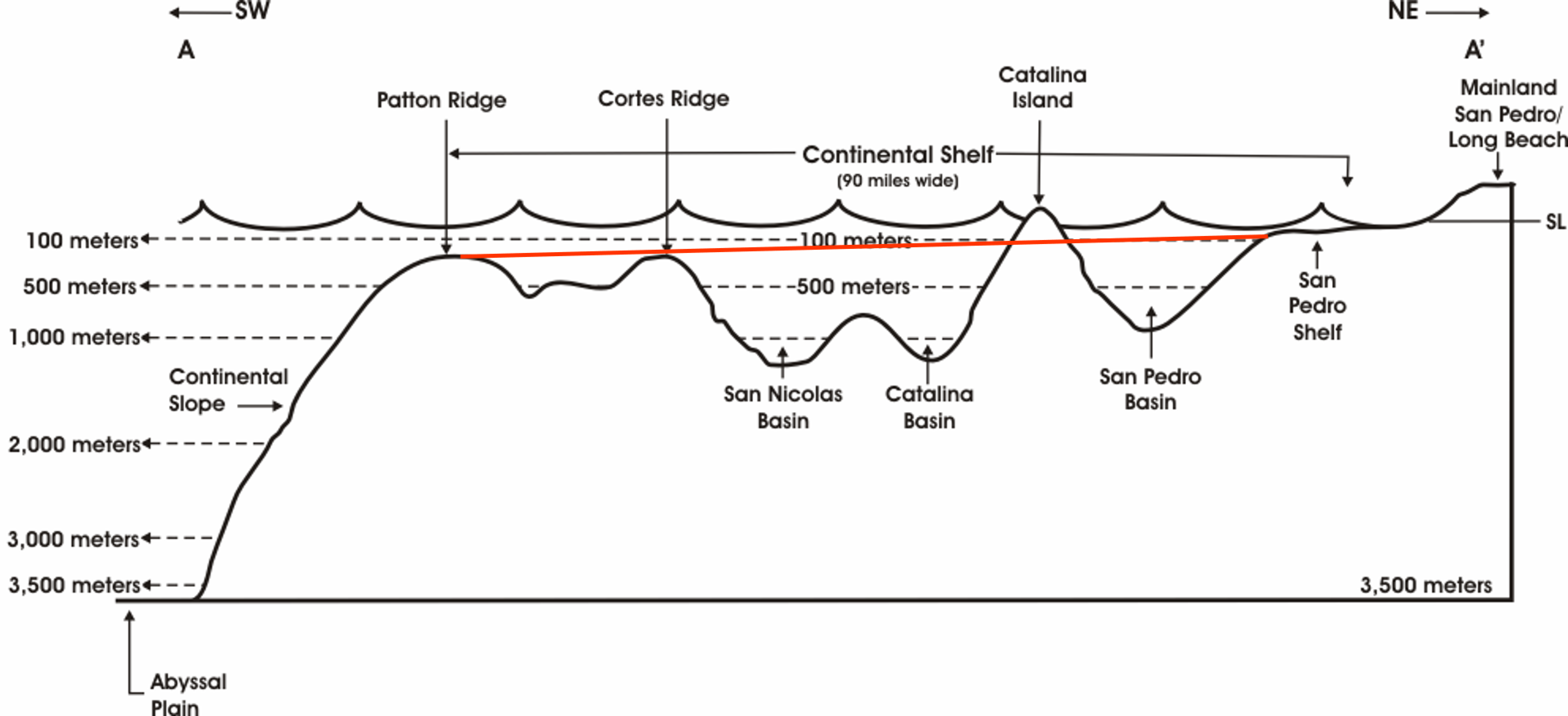
Image source: "Profile of the Southern California Margin From San Pedro to the Patton Escarpment" by CSULA Geology Department Faculty is licensed under CC BY-NC 4.0
Go back to the map above and take a look at the pattern of the faults. The faults, mountains, and islands south of Los Angeles (where UCR, UCI, and UCSD are on the map) trend NW-SE. This trend is the same as nearly all of the mountains along the west coast of the US, Canada, Central, and South America. Now, look at the faults, mountains, and islands where UCLA is located on the map. They all trend in an E-W direction.
What caused this nearly 90° rotation? Geologists still aren't sure, but rotation began about 20 million years ago. This animation created by Tanya Atwater of UCSB Geology shows one possible explanation.
Here is the map again, this time with the location of the Transverse Ranges included. The San Andreas Fault steps to the left in this area, causing compressional tectonic stress. The Transverse Ranges Province and the Los Angeles Basin, therefore, have all three fault types (normal, reverse, and thrust) underfoot.
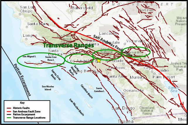
Image adapted from: "Historical Earthquakes & Significant Faults in Southern CA" by Southern California Earthquake Data Center is licensed under CC BY-NC 4.0
The "typical" continental margin has a shelf, slope, and rise, with submarine canyons located on the slope and the fans on the rise. What about the Southern California margin? Take a look at the image below. It shows bathymetry derived from multibeam sonar. Where are the canyons and fans? Are they at the edge of the continental shelf (aka the Patton Escarpment)?
Note the flat areas next to the coast (colored brown); 11,000 years ago, the Santa Monica and San Pedro shelves were above sea level. This is where the coastline was as the ice sheets began to melt. Slowly, over the last 11,000 years, this area was covered in approximately 70 meters of seawater.
Think about what our continental shelf looks like (or, just scroll up to the profile above). The Los Angeles River, the San Gabriel River, and Coyote Creek (left to right) are shown on the map below. For any of those rivers to form a canyon in the Patton Escarpment, they would have to go down into the San Pedro Basin, up over Catalina Island, down into the Catalina Basin, then the San Nicolas Basin, up and over the Cortes and Patton Ridges before reaching the Patton Escarpment. That's a long, complicated way to go, and rivers are lazy - they like the path of least resistance.
Instead, the Los Angeles River, the San Gabriel River, Coyote Creek, and the Santa Ana River (not shown on map) enter into the Pacific and flow over the San Pedro Shelf and carve out canyons into its slope instead.
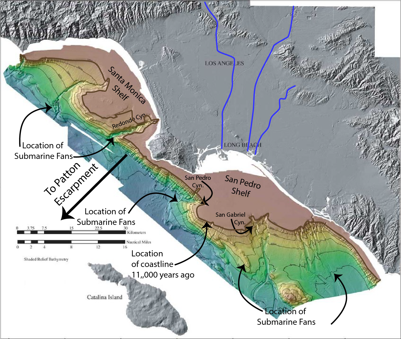
Image source: "la-shd.jpg" by U.S. Geological Survey is in the Public Domain, with annotations by Sonjia Leyva.
copyright Sonjia Leyva 2022 |
|