Coastal Processes
Beach Processes
The beach is a buffer zone comprised of loose particles (sediments) that protects the onshore area. It is also in equilibrium - that is, the amount of material brought in (the amount of material removed. Most beaches are typically wide in the summer and narrow in the winter, and storms can induce major changes. At any point in time, a beach may be:
Coasts
Coasts a large geographic areas that are classified based upon whether they are actively eroding (emergent or erosional) or not (submergent or depositional).
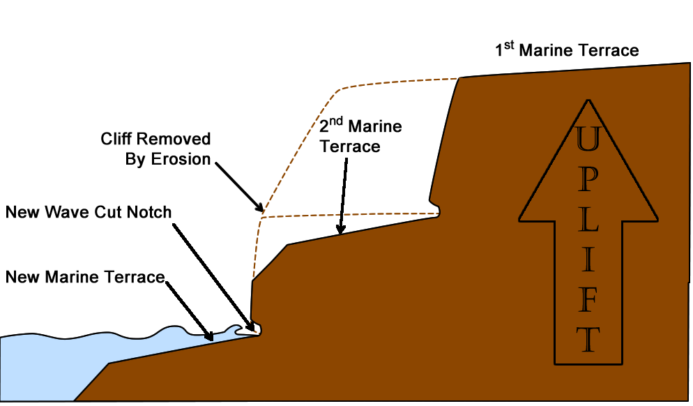
The Southern California coastline is classified as emergent or erosional. Much of the coast is being uplifted by the numerous faults that cut through the land. Waves tend to hit the cliffs in more or less the same area all the time, so erosion is concentrated in these areas.
The constant back and forth motion of the waves plane the bedrock just under the ocean's surface, forming a feature called a marine terrace or a marine platform. Tide pools are common in the nooks of these platforms. As the coast is uplifted by tectonic activity, the beach and terraces are uplifted as well. The terraces are now (literally) left high and dry and a new terrace will form in the new shoreline.
Wave action will also lead to the formation of a wave cut notch. As the rock in the cliff is undermined, a sea cave will form. Erosion continues, and the sea cave will continue to the other side, forming a sea arch. Finally, sometimes the roof of either the cave or the arch will fail, creating a sea stack (or sea island).
Beach Processes Occur Due To Waves
Waves help to erode the shoreline by physically pounding on the rocks and sediments that make up the coastline. Waves do not always travel in a straight line - they can bend in response to changes in the coastline or other factors.
Refraction: Bending of waves due to difference in density/composition/speed.
In the open ocean, the wave train begins to move towards the shore. So long as the wave is moving through water that is greater than 1/2 their wavelength the downward motion of energy is released before it reaches the seafloor. However, the downward motion of energy is interrupted and the wave slows as water becomes more shallow. Friction between the wave and the seafloor causes the wave to slow down and bend to become more parallel with the shoreline. This bending of the waves is called refraction, and is the reason for the development of the swash, backwash, longshore drift, and longshore current. |
|

Source |
| |
|
|
Reflection: Bouncing back of waves.
|
|

Source
|
 |
This can change with storms, but, most of the time, waves typically break along a coastline in the same place with the same amount of energy. In the case of cliffs the waves break at the same area, increasing erosion and eventually undermining the overlying rocks (see image above). To the left is an image from Point Dume, California, showing a rock fall due to this process.
For man-made structures such as breakwaters or sea walls, the wave's energy isn't released as effectively, and is reflected back into the next set of on-coming waves. Now there is even more wave energy hitting the seawall (or other structure), increasing erosion and eventually causing the structure to fail. |
| |
|
|
|
Diffraction: Change in wave direction as it passes through or around a solid object.
In the open ocean, the change in wave direction has been used for millennia by sailors to find land, mostly islands. The image to the left shows a series of wave trains (top of image) approaching several islands. First, the waves refract, or wrap around, the islands. This changes their paths so that when they exit out the other side they are going in different directions. Where two sets of wave trains meet, they cause interference - sometimes it's constructive, sometimes it's destructive, and sometimes it's mixed. Sailors learn to read these patterns and therefore can estimate where land will be. |
|

|
| |
|
|
Sediment Transport
Waves can interact with each other, causing destructive, construction, or mixed interference patterns. These types of interference can also affect the coast, either increasing erosion or increasing deposition.
The Longshore Current moves down beach and is caused by waves hitting beach at angle (refraction). This current flows parallel to the shore and transports sediments down the coast. The longshore current moves substantially more sediment than does the longshore drift. How much? Around 150,000 to 300,000 m3/yr on the Atlantic seaboard and 750,000 m3/yr offshore Oxnard, California.
Here is a video to explain this process visually: https://www.youtube.com/watch?v=BlDzaIE-ajQ
As waves break and rush onto the shore, the not only move water but a little bit of sediment onto the beach. This is called the swash. The movement it perpendicular to shoreline (toward and away). Then the water pulls back away from the shore, moving water and a little bit of sediment off of the beach. This motion is called the backwash. The movement is parallel to shoreline (up-coast or down-coast)
During periods of light wave activity the swash dominates. Sediment is moved toward shore, creating a wider beach. Light wave activity is associated with fair weather and is called a “Summertime” beach. During times of heavy wave activity the backwash dominates. Sediment is moved away from shore, creating a narrower beach. The sediment is forms offshore sand bars where it is stored until the summer. Heavy wave activity is associated with stormy weather and is referred to as a “Wintertime” beach.
This zig-zag motion of sediment via the swash/backwash is called Longshore (or beach) Drift.
Longshore Drift
+
Longshore Current
= Longshore Transport |

Diagram demonstrating longshore drift 1=beach 2=sea 3=longshore current direction 4=incoming waves 5=swash 6=backwash. By USGS/USGov, modified by Eurico Zimbres - http://commons.wikimedia.org/wiki/Image:Longshore.gif, Public Domain, Link |
Together, the longshore drift and current transport sediment along a coastline until it reaches a submarine canyon. All of the sediment gets funneled down the canyons and onto the deep sea floor. Then the process starts up again just down shore from the canyon. Sections of coast in which sand input and sand output are balanced are referred to as coastal cells.
Longshore drift is often interrupted by jetties, groins and breakwaters. This causes an undesirable build up of sand in areas where there shouldn't be.
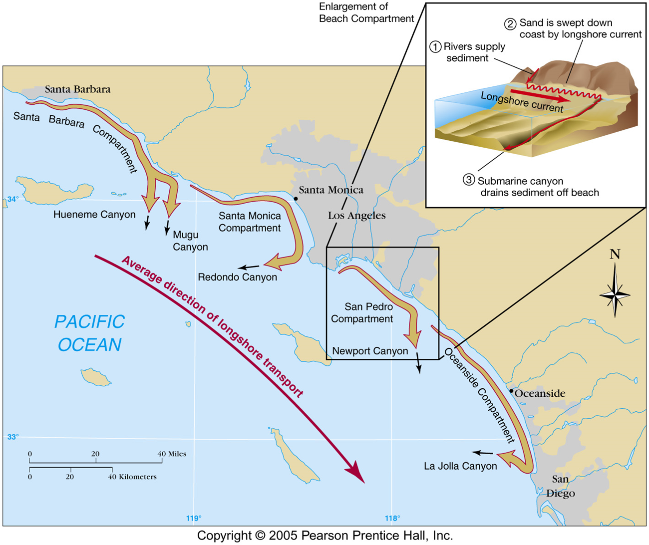
Sediment is "lost" into submarine canyons. Fans at canyon mouths are proof of sand loss down canyons. Different canyons remove sediments at different rate, but the amount of sediment being removed by La Jolla canyon just north of San Diego is enormous: 150,000 m3/yr.
Another way for a beach to loose sand is through rip currents. Rip currents or other strong currents carry sand offshore into deep water. Look for any of these clues to identify rip current:
- a channel of churning, choppy water
- an area having a notable difference in water color
- a line of foam, seaweed, or debris moving steadily seaward
- a break in the incoming wave pattern
Finally, wind can transport sand to dunes. Sand migrates inland, burying everything and is lost to the coast. The Oregon dunes have migrated 3 miles inland, taking with it sand that otherwise would have remained on the beach. Oregon dunes is a huge area - the most extensive dune field is 50 miles long. Thousands of east coast houses are built directly on active dunes. Dunes are ephemeral features and erode easily - not the best location to build a settlement.
Sediment loss can also be due to human activities. Flood control dams, sand & gravel quarries, paved river channels, and erosion prevention structures such as breakwaters, seawalls and groins can all disrupt the sediment flow, causing erosion in some areas and a build up of sediment in others.
The Inner and Outer beaches here at Cabrillo are due to the breakwater that was built in the 1920s. Even though they are artificial beaches, meaning that sand was imported to create them, natural processes still govern the sediment size, slope steepness, and wave energy.
- Erosion/Deposition: Build up of sand can be seen on Outer Beach on the south side of the breakwater, while there is little to no sand paralleling the breakwaters on the inside of the harbor near the Inner beach.
- Wave energy & Sediment size: For the Outer beach, wave energy fluctuates from mild to strong, depending on the season. Wave are always very weak in the Inner beach due to the breakwater. The stronger waves at the Outer beach washes away the smaller and lighter grains, leaving behind the larger, heavier grains on the beach. The Inner beach's weak waves aren't strong enough to move anything other than the very smallest and lightest particles, so finer sediments predominate on the beach.
|