Los Cerritos Wetlands
6720 Pacific Coast Hwy, Seal Beach, CA 90740; http://intoloscerritoswetlands.org/the-los-cerritos-wetlands/

The original wetlands formed at the mouth of the San Gabriel River and provided refuge for numerous migratory species in addition to habit, breeding grounds, and nesting grounds for many others. Once estimated to be 2,400 acres in size, the Los Cerritos Wetlands have been reduced to a mere 44 acres, and are one of two remaining salt marshes in Los Angeles County.
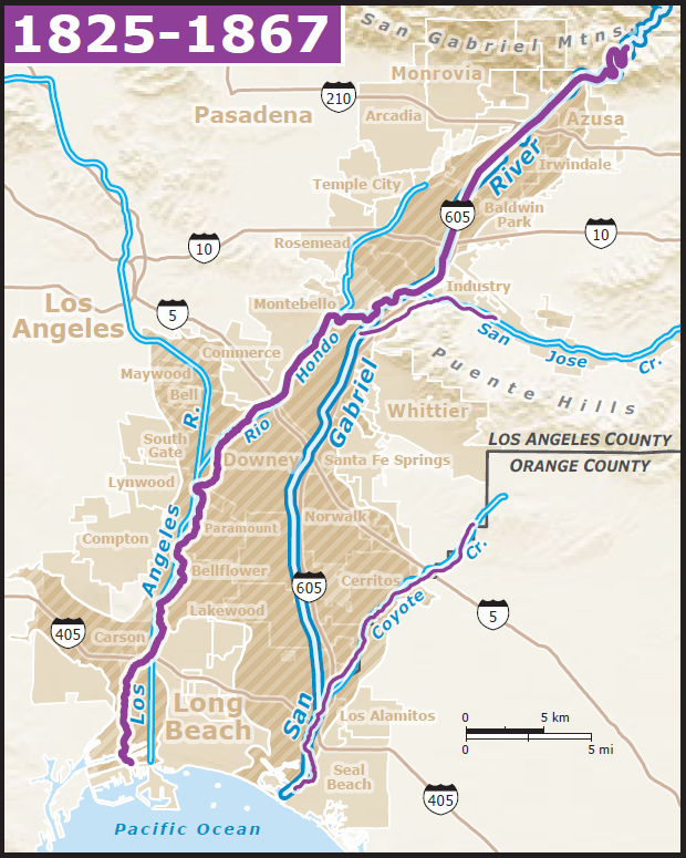
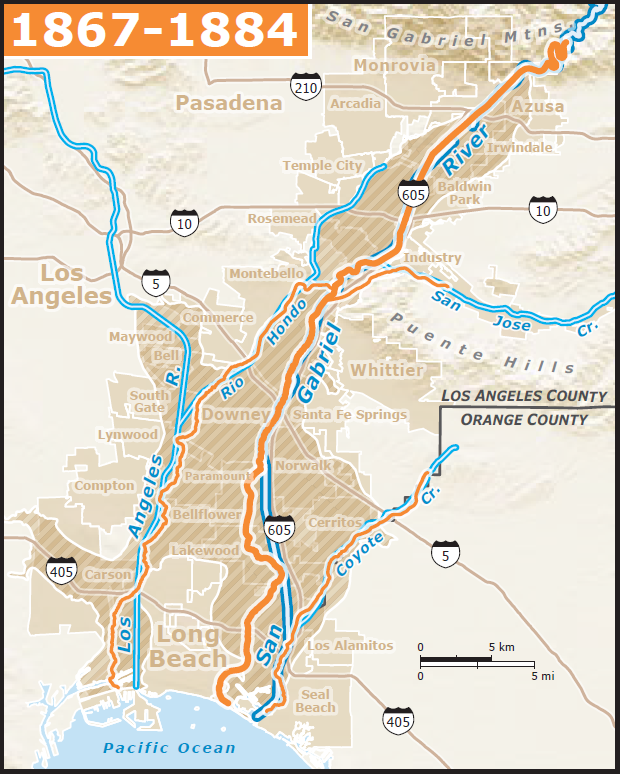
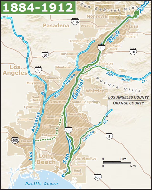
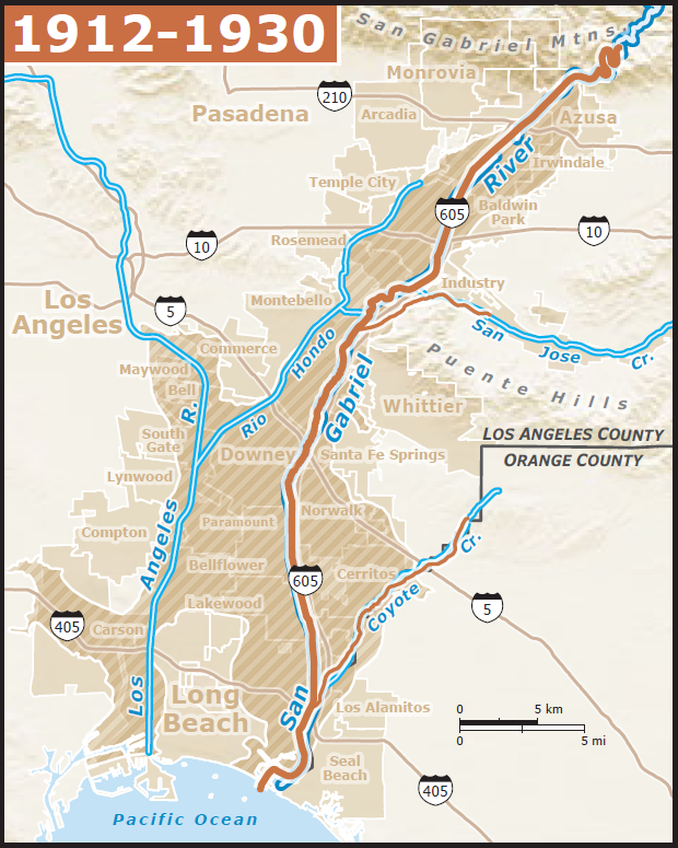
Originally, the San Gabriel River merged with the Los Angeles River but realigned in 1867 a few miles from its present location. By 1884, the river realigned again to merge with Coyote Creek. The river was channelized in the 1930s as a part of the Los Angeles County Flood Control Program.
 |
 |
 |
 |
|
Re-alignment of the San Gabriel River from 1825 to 1930. Maps from Grossinger et al. (https://www.sfei.org/sites/default/files/biblio_files/499_historical_ecology_0.pdf)
|
| |
 |
Map from Grossinger, R. M., et al., 2007)
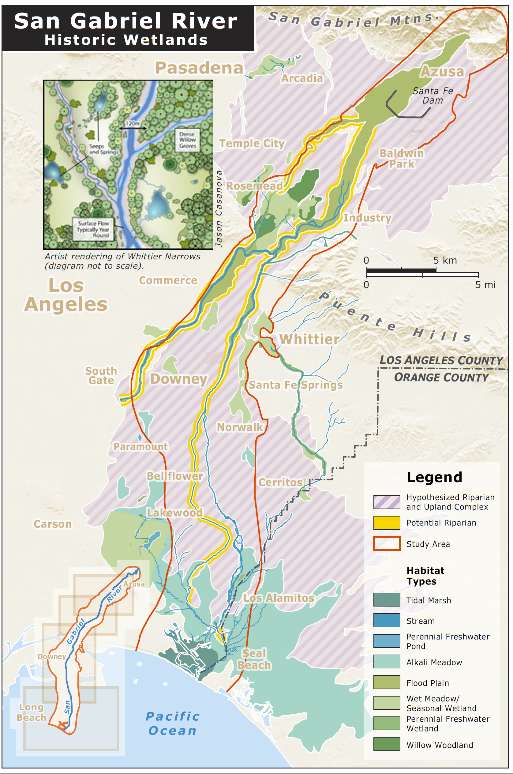
This map shows historic wetlands along the San Gabriel River. Los Cerritos wetlands are located at the very bottom in the dark green area left of "Seal Beach" and adjacent to the ocean. This area was/is a tidal marsh - a brackish water-logged area subject to the influences of the tides.
|
|
| Today, Los Cerritos Wetlands consists of two main areas, Steamshovel Slough and Zedler Marsh, in addition to several brackish seasonal ponds. Zedler Marsh is a coastal sage habitat and is a buffer for wetland against trash, etc. Los Cerritos is classified as a "degraded wetland" - a wetland area that has been impaired due to human activity. The area has surrounded by an oil field in addition to the urban landscape that is Long Beach for over a hundred years. |
 |
|
Zedler Marsh, looking east. Lighter green areas are algae, while darker green areas are marsh plants such as pickleweed.
The white bird in the photo is a snowy egret. Note the pieces of trash. While the conservancy does it's best to keep the area trash-free, nearly all of it arrives via the wind or currents.
While it's hard to tell from a photo, how fast do you think the water is moving here? Fast, like at Stop 1 on the San Gabriel River? Medium, like at Fish Canyon Spreading Grounds? Is it moving at all?
|
| |
 |
A close up of Zedler Marsh showing the mud substrate. Now do you think you have a better idea of how fast the water is moving? Waters in wetlands are pretty quiet, with the only movement due to wind-induced waves (very small) or tides. Wetlands are designed to slow down the river before it enters the ocean. Sediments are deposited in these areas as well, limiting the amount discharging into ocean waters.
The rocks you see in the photo are a part of the trail and not typical wetland sediment. While there's no quadrant in the image, what would you estimate the grain size to be? |
| |
 |
| Part of the restored areas. This area only floods seasonally. |
| |
 |
| Photo of the Los Angeles Department of Water And Power plant along the San Gabriel River (looking east). Warm water from the plant's discharge has attracted green sea turtles (Chelonia mydas) to the San Gabriel River. The turtles range from the tropical waters of Mexico and Hawaii to as far north as Los Angeles. Efforts to clean up the river have increased the colony's numbers to about 100. The Aquarium of the Pacific has a Citizen Scientist program where you can help count the turtles. |
|