Background Information:
The definition of what is a “wetland” varies, depending upon who is doing the classification. In general, a wetland is a biome that is partially in water either all year or seasonally. There are two basic groups: Tidal wetlands are near the coast and include fresh, brackish, and salt water. Non-tidal wetlands are located next to lakes and rivers, but can also be found far from water bodies, as it the case with playas and low-lying areas where the water table is close to the surface.
All wetland areas have several important functions.
- Wetlands slow flowing water down before it reaches the coast. This limits coastal erosion and helps to protect the beach and offshore environments.
- The shallow, calm waters of wetlands can act as breeding grounds for some species, and nurseries for the young of many fish species. The shallow, quiet waters are the perfect location for the young of many fish and invertebrate species to spend their youth, protected from larger predators due to the reduced water depth, amount of silt in the water, and numerous plants.
- Rivers carry sediment in addition to water. Wetlands function as a filter for sediments entering the ocean. Lagoons, marshes, and other quiet water environments are also low energy environments, so sediments are deposited easily. This limits the amount of sediment entering into the coastal waters and keeps tidal and kelp ecosystems clear and sediment-free.
- Coastal wetland areas offer protection from storms. Areas such as the beach, sand dunes, and wetlands are comprised of loose sediment which can shift around during storms. The erosion of these areas helps to slow down and limit the erosion of inland areas.
- Wetland habitats provide a place for birds to rest, and to find shelter, food, and water. This is especially important for migrating animals who travel long distances during their migration.
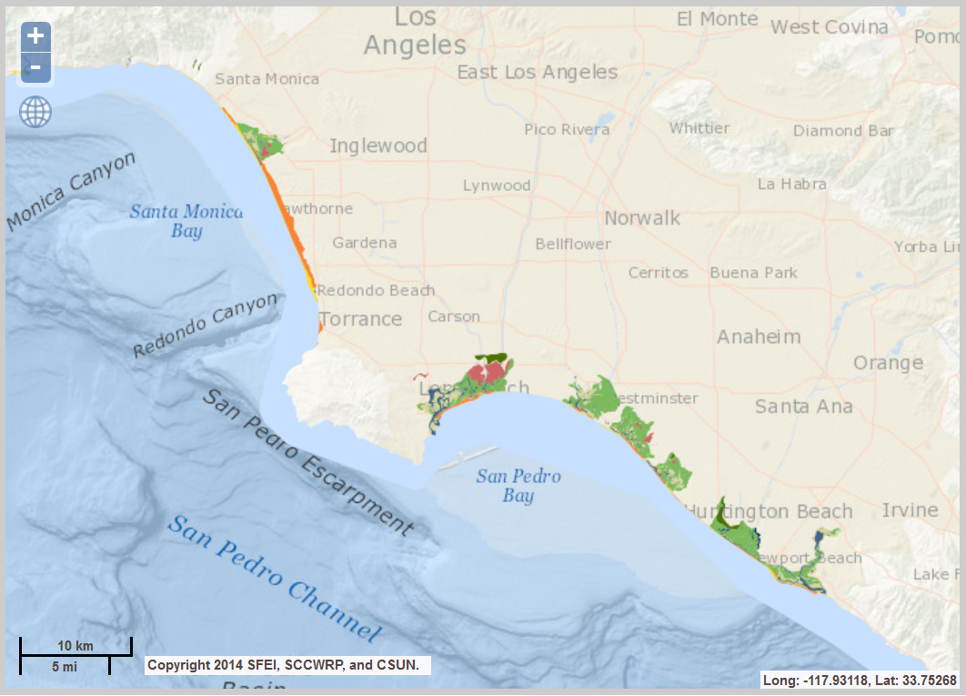 |
Map showing historic wetland areas of Los Angeles and Orange Counties. Data from: http://www.caltsheets.org/socal/
|
|
 |
|
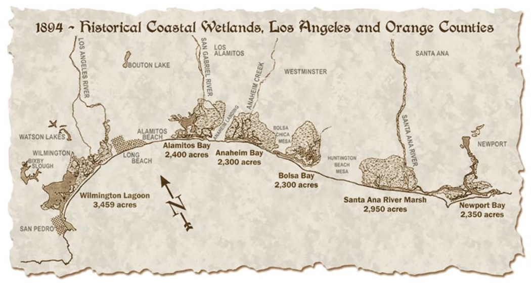
Another map showing the location of coastal wetland areas in 1894. Image from: http://www.amigosdebolsachica.org/history.php
|
Wetlands are fertile areas, providing an abundance of food for a diverse ecological community. The first humans arrived in the Southern California region 8,000 to 10,000 years ago, but were eventually replaced by the Tongva beginning around 1 AD. The arrival of the Spanish in the 16th Century marked the beginning of adverse change in the region. The Santa Monica Bay was visited by Portuguese explorer Juan Rodriguez Cabrillo in 1542. At that time, the much coastal areas of the bay were marshland. Land that had belonged to the Tongva was parceled out at land grants, either to the Church or to influential (rich) men, first from Spain and then from Mexico. As time went on these land grants were sold off as cities in the Southern California region began.
One of the most damaging developments to coastal Southern California was the building of the Port of Los Angeles in 1907. The is one of the most important ports in the world, moving 190 metric tons annually. Then, the discovery of oil and residential/commercial development of the coastal areas of what is now Los Angeles and Orange Counties in the 1920s severely damaged and polluted the remaining wetland areas. Continued development along the coast has destroyed nearly all of the coastal ecosystems in the area. According to the Southern California Coastal Water Research Project, the Southern California bight supported 19,591 hectares of estuarine habitats. Since 1850, about 48% of these areas have been lost, with the vegetated wetlands (aka salt marshes) suffering the most. |
|
|